- Messages
- 12
- Country

First of all I don't want to miss to say thank you very much for the great development of SBuilder. Its an amazing and outstanding piece of software.
Well, we use it to create an open source scenery for D, AT and CH (and may be also other countries) based on the data available from Open Streetmap.
After creating some nice Shp-files by our own internal process we use SBuilder for the last step - generating the final BGLs. The final process in short words is to "append" these shp files to a blank project in SBuilder in alphabetical order.
By this process we have already finished the whole area for all countries in DACH (vers 0.1), which is already very nice result for VFR pilots. Finally we recognized some wrong filled rectangle polygons.
Pls check the following BGL with TMFVIEWER:
www.freyt.de/CVX_switzerland.BGL
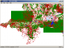
Also we have prepared some screens to point out the problem we see:
www.freyt.de/screen_CH.png
www.freyt.de/screen_germany.png
When you compare the BGL with the original shp files we imported ( pls refer: www.freyt.de/shp_data_package_switzerland.rar) you will see, that the data itself seems to be fine. Hopefully ;-) Also the rendering of the data in SBuilder seems to be ok - just the generated BGLs seem to be a bit corrupted. When you fly over these areas in FSX, you'll see some kind of areas filled with water, etc.
Well, would be nice to get your response. Would be great, if you could find a patch or some instructions for modification of our shp files in order to avoid these problems. Then we could launch our free bgls for public soon. I can already promise the result seems amazing for VFR, but also for IFR pilots
Once again: I love SBuilder. We didn't found any other software for doing such great job for our purpose...
Greetings
Markus
Well, we use it to create an open source scenery for D, AT and CH (and may be also other countries) based on the data available from Open Streetmap.
After creating some nice Shp-files by our own internal process we use SBuilder for the last step - generating the final BGLs. The final process in short words is to "append" these shp files to a blank project in SBuilder in alphabetical order.
By this process we have already finished the whole area for all countries in DACH (vers 0.1), which is already very nice result for VFR pilots. Finally we recognized some wrong filled rectangle polygons.
Pls check the following BGL with TMFVIEWER:
www.freyt.de/CVX_switzerland.BGL
Also we have prepared some screens to point out the problem we see:
www.freyt.de/screen_CH.png
www.freyt.de/screen_germany.png
When you compare the BGL with the original shp files we imported ( pls refer: www.freyt.de/shp_data_package_switzerland.rar) you will see, that the data itself seems to be fine. Hopefully ;-) Also the rendering of the data in SBuilder seems to be ok - just the generated BGLs seem to be a bit corrupted. When you fly over these areas in FSX, you'll see some kind of areas filled with water, etc.
Well, would be nice to get your response. Would be great, if you could find a patch or some instructions for modification of our shp files in order to avoid these problems. Then we could launch our free bgls for public soon. I can already promise the result seems amazing for VFR, but also for IFR pilots
Once again: I love SBuilder. We didn't found any other software for doing such great job for our purpose...
Greetings
Markus


 Just let me know, if you want me to change a bit....
 Actually just three easy steps: