

- Messages
- 163
- Country

As you probably see in the showroom section, I've started do design the ground layer in my Milan VFR scenery.
Because I want to maintain a resolution higher than the default fs9 4.8m/px I've decided for the ground poly solution.
I have a large bmp, covering an huge area 17km x 15km, bitmap is not geo referenced, but this was not a problem, I have made the geo data by myself.
In Gmax I've designed a mesh large exactly as the area covered by bitmap.
The mesh plan is subdivided in 15 sectors and I divided the bitmap in 15 sectors each one cover one of the mesh sector.
I've exported the mesh with fs2002 gamepack, then tweaked the asm files and the scenery in Fs2004 is perfect and correctly placed, just for reference I've also the Ultimate Terrain Europe installed, and during night UTEurope lights perfectly merge with my photo scenery scenery.
But... I see a strange behavior in my Fs2004, If I load my aircraft in an airport located inside my scenery it load pretty fast, but when loaded if I right click to open menus or If I push "Alt" to open Fs menu, the simulator took about 10 seconds to display menu, same if I close the menu, I have at least 5 to 10 seconds prior the simulator is back to normality...
Normally without my photoscenery activated those operation take max 1 second, so maybe my scenery have problem of some kind...
The question is? may large Bgl cause general slowness? is there a maximum size for a ground poly?
I put some other details:
Ground poly count only 180 polygon.
Texture are 15 1024x1024 dxt3 files, so they have a little impact.
Ground poly is a single file, with only 1 reference point, I have tried to divide it in 15 blocks and compiled as 15 different bgl, but with only 1 reference point, so the corner sectors have its reference point outside its limits because is in the middle of the whole scenery, but the problem of menu slowness remain.......
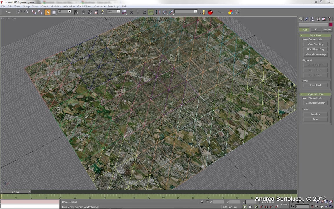
this is a gmax shot, I've colored sectors so you can see the subdivision, the Geo reference point is the center of the image, every sector is 3,4km X 5 km, corner sector reference point is 8km far from the sector, I don't know if this may lead to problems.
Sorry if the question is too long, hope someone can help me
Thanks, Andrea.
Because I want to maintain a resolution higher than the default fs9 4.8m/px I've decided for the ground poly solution.
I have a large bmp, covering an huge area 17km x 15km, bitmap is not geo referenced, but this was not a problem, I have made the geo data by myself.
In Gmax I've designed a mesh large exactly as the area covered by bitmap.
The mesh plan is subdivided in 15 sectors and I divided the bitmap in 15 sectors each one cover one of the mesh sector.
I've exported the mesh with fs2002 gamepack, then tweaked the asm files and the scenery in Fs2004 is perfect and correctly placed, just for reference I've also the Ultimate Terrain Europe installed, and during night UTEurope lights perfectly merge with my photo scenery scenery.
But... I see a strange behavior in my Fs2004, If I load my aircraft in an airport located inside my scenery it load pretty fast, but when loaded if I right click to open menus or If I push "Alt" to open Fs menu, the simulator took about 10 seconds to display menu, same if I close the menu, I have at least 5 to 10 seconds prior the simulator is back to normality...
Normally without my photoscenery activated those operation take max 1 second, so maybe my scenery have problem of some kind...
The question is? may large Bgl cause general slowness? is there a maximum size for a ground poly?
I put some other details:
Ground poly count only 180 polygon.
Texture are 15 1024x1024 dxt3 files, so they have a little impact.
Ground poly is a single file, with only 1 reference point, I have tried to divide it in 15 blocks and compiled as 15 different bgl, but with only 1 reference point, so the corner sectors have its reference point outside its limits because is in the middle of the whole scenery, but the problem of menu slowness remain.......
this is a gmax shot, I've colored sectors so you can see the subdivision, the Geo reference point is the center of the image, every sector is 3,4km X 5 km, corner sector reference point is 8km far from the sector, I don't know if this may lead to problems.
Sorry if the question is too long, hope someone can help me
Thanks, Andrea.
Last edited:


 this is due the fact I split the big 17km x 15km in 15 blocks, to display them correctly in fs9 I left them in the Gmax position, I will try to place them with a reference point located in the center of every block, but will be very hard to calculate the displacement from meters to degrees, I hope fs9 have enough precision in degrees reference system.....