• Which the release of FS2020 we see an explosition of activity on the forun and of course we are very happy to see this. But having all questions about FS2020 in one forum becomes a bit messy. So therefore we would like to ask you all to use the following guidelines when posting your questions:

    • Tag FS2020 specific questions with the MSFS2020 tag.
    • Questions about making 3D assets can be posted in the 3D asset design forum. Either post them in the subforum of the modelling tool you use or in the general forum if they are general.
    • Questions about aircraft design can be posted in the Aircraft design forum
    • Questions about airport design can be posted in the FS2020 airport design forum. Once airport development tools have been updated for FS2020 you can post tool speciifc questions in the subforums of those tools as well of course.
    • Questions about terrain design can be posted in the FS2020 terrain design forum.
    • Questions about SimConnect can be posted in the SimConnect forum.

    Any other question that is not specific to an aspect of development or tool can be posted in the General chat forum.

    By following these guidelines we make sure that the forums remain easy to read for everybody and also that the right people can find your post to answer it.

Few questions about SBuilder

Messages
29
Country
poland
It's my first post here, so I want to say hello :)

I want to make photoscenery of my hometown, and I've found SBuilder very good, and powerful tool. I've succesfully aligned phototextures, but I have few questions.

1. Is it possible to add landclass area over photoscenery? I'd like to add few places with forests, and urban areas.

2. How to get rid of default roads?

3. How to add a small lake?

4. I'd like to use RWY12 object libraries with SBuilder, I have RWY12 installed, and working, but SBuiler doesn't recognize it (I have set correct path to RWY)

I know these are noobish questions, but this is my first scenery :)

And sorry for my English :)

Thanks!
 
1) You can do this with polygons.

2) Make an exclude polygon and exclude layer 6 (I think).

3) You can do this with a water mask or a line and polygon.
 
3. How to add a small lake?

Start Sbuilder, click new, this box will come up.

Sbuilder1.jpg


Type the name for your project. Click OK

Sbuilder2.jpg


Start FS9 & go to any location. Place the aircraft on the ground and note the elevation. Click view, show aircraft.

Sbuilder3.jpg


You'll see a crosshair which is your aircrafts location in FS9.

Sbuilder4.jpg


The location in FS9

Sbuilder5.jpg


Click poly.

Sbuilder6.jpg


Click the left mouse button and draw an object, left clicking as you go. Right click to complete the object.

Sbuilder7.jpg


Right click on the object line to bing up a menu box.

Sbuilder8.jpg


Click properties.

Sbuilder9.jpg


This menu will come up.

Sbuilder10.jpg


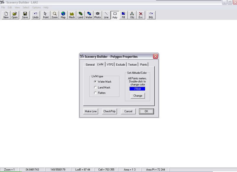
Type the name of the polygon and click LWM

Sbuilder11.jpg


This menu will come up.

Sbuilder12.jpg


Type the altitude for the lake in the blue box. I typed in 770.8 metres for my location. Click change. Click OK

Sbuilder13.jpg


Click select, all polygons.

Sbuilder14.jpg


You'll note the polygon dots have changed colour.

Sbuilder15.jpg


Click BGL, this box will pop up.

Sbuilder16.jpg


Click copy files to BGL folders. ( you can choose any folder you want to have your files located by clicking on file, properties, folders, on the top menu bar of Sbuilder.)
Click compile.

Sbuilder17.jpg


Place the file that Sbuilder compiled into an active folder in the Addon Scenery folder in FS9.

Save your flight in FS9 so you can come back to your location. Close FS9, start FS9, choose your saved flight & you should see a new lake.

Sbuilder20.jpg


Sbuilder21.jpg


Sbuilder22.jpg


Last thing to do is add a shoreline using the line tool.

I've got a guide for that too if you're interested
 
Wow! Thats a great tutorial!

Thanks very much!

Guide for shorelines would be great too.
 
Last edited:
Making a shoreline for your lake.

Right click the poly, this menu will come up, click onto Properties.

Shoreline003.jpg


This menu will come up.

Shoreline004.jpg


Click the General tab, click Make Line.

Shoreline005.jpg


Click Line.

Shoreline006.jpg


Right click the line, this menu will come up, click Properties

Shoreline008.jpg


This menu will come up, type the line name, click VTP2.

Shoreline009.jpg


Click Assembled, click into the long white box to the left of Assembled, this window will come up. Choose your shoreline texture. Click Ok.

Shoreline009a.jpg


Your chosen texture will appear.

Shoreline010.jpg


Click the Points tab. In the Set Width box type 80 (or any number you like) click Change, click Ok.

Shoreline011.jpg


Click Select, click All Lines.

Shoreline16.jpg


Click BGL, click Copy files to BGL folders.

Shoreline18.jpg


Place the file that Sbuilder compiled into an active folder in the Addon Scenery folder in FS9. Go to your lake & check out your new shoreline.

Shoreline23.jpg
 
Hi,

Have still a question...
The fact is that a scener in FSX is different and better than the one in FS9 for the part that I want to change into the same scenery as in FSX.
Is it possible to use the FSX scenery and make this lake for FS9 (as a copy or overwriting with SBuilder ?).
Or can I use a screenshot ? Or... ?


Greetz. José.
 
Hi,

Still not found: can I take a screenshot in FSX and use it in FS9 + SBuilder and make the changes ? Which format must the bitmap have ? How to do scale and fit into the FS9 scenery ? How to place a background image in SBuilder for FS9 ? Or is that impossible ?

Question 2: If the scenery has an altitude of let's say 13 ft and I set the water poly altitude on zero (sealevel)... will this be displayed or have I to do more such as exclude ?

Greetz. José.
 
Last edited:
4. I'd like to use RWY12 object libraries with SBuilder, I have RWY12 installed, and working, but SBuiler doesn't recognize it (I have set correct path to RWY)


Thanks!

I have the same problem i´ve tried everything with the Rwy 12 path, didn´t work
 
I have the same problem i´ve tried everything with the Rwy 12 path, didn´t work

Can you explain a bit more what the problem is? You need to point to the RWY12 folder that contains the XML as I recall
 
Hi,

I just tried to make a little lake.
Have a question:

I typed in 770.8 metres for my location.

Living in Belgium (Europe), must I not set the altitude = 770,8 meter (with a comma) ?
Because there is plenty of water elsewhere but not in a lake.

Greetz. José.
 
Well the Rwy 12 objects window is NOT active in the sbuilder, only the library objects is, the path is set correctly but sbuilder does not recognizes it

Gus

PD i can use ScenGenx anyway to do that, the thing is the background bitmap calibration tool in sbuilder is better than the "manual window" in SGX, not a big deal though.
 
Hi,

I just tried to make a little lake.
Have a question:


Living in Belgium (Europe), must I not set the altitude = 770,8 meter (with a comma) ?
Because there is plenty of water elsewhere but not in a lake.

Greetz. José.

No, don't use a comma, use a decimal point.
 
http://www.ptsim.com/sbuilder/gmaps.htm - Help with obtaining calibrated images
http://www.fs-freeflow.com/forum2/index.php?topic=1376.0 - Help with obtaining calibrated images
http://www.fs-freeflow.com/forum2/index.php?topic=618.0 - Help with obtaining calibrated images


Placing a calibrated map into Sbuilder.

Start Sbuilder, click New, type the name for your project.

Tassie-Lakes.jpg


Click Map. Left click anywhere in the Sbuilder window.

Tassie-Lakes2.jpg


Locate the folder with your calibrated map, click Open.

Tassie-Lakes3.jpg


Your map will show up in Sbuilder, click OK.

Tassie-Lakes4.jpg


This Box will come up, enter your co-ordinates into the N,S,W,E, boxes. I prefer to use Lat/Lon in decimal degrees.

Tassie-Lakes5.jpg


Click Create Data File.

Tassie-Lakes5a-1.jpg


Sbuilder will save a text file in the same folder you have the map bmp. If you do not do this your calibration will be lost the next time you open Sbuilder.

Tassie-Lakes5b.jpg


Tassie-Lakes5c.jpg


Click OK to close the Box & place the map.

Tassie-Lakes5.jpg


You will most likely be left with a blank screen.

Tassie-Lakes6.jpg


Don't worry, your map is just in a different location than you. Click View, Go to Position.

Tassie-Lakes7.jpg


This Box will come up, copy & paste your North & West co-ordinatates from the text file Sbuilder saved in your map bmp folder into the Lat Lon boxes. North for Lat, West for Lon.

Tassie-Lakes8.jpg


Click the Convert button to the right of the Lat Lon boxes. Click ok.

Tassie-Lakes9.jpg


You'll be transported to the location of your map.

Tassie-Lakes10.jpg


Press & hold the wheel button of your mouse to move the map. Use the wheel to zoom in & out.

Tassie-Lakes11.jpg


Tassie-Lakes12.jpg


Click the Poly button & start tracing out your new lake.

Tassie-Lakes13.jpg
 
Hi,

Have tested it with a comma and there was indeed no change.
Maybe the altitude is wrong. All the screenshot I see of a lake are situated in mountains. However nearby my location is another lake and the area is rather flat.
If I notice the altitude with a Cessna, should I use the mentioned altitude of is that too high ?
As I said: the lake itself is not displayed but outside the exclude area is plenty of water.

Regards. José.
 
Well the Rwy 12 objects window is NOT active in the sbuilder, only the library objects is, the path is set correctly but sbuilder does not recognizes it

Ah you must select the RWY12 option from the General tab ( the first one that comes up when you try to place an object) other wise the RWY12 tabe will be greyed out. You cannot just select the tab.
 
Hi,

Have tested it with a comma and there was indeed no change.
Maybe the altitude is wrong. All the screenshot I see of a lake are situated in mountains. However nearby my location is another lake and the area is rather flat.
If I notice the altitude with a Cessna, should I use the mentioned altitude of is that too high ?
As I said: the lake itself is not displayed but outside the exclude area is plenty of water.

Regards. José.

Place the aircraft on the ground and note the altitude. Use that altitude for your lake. You can make a flatten and use the flatten altitude for the lake.
 
Back
Top