• Which the release of FS2020 we see an explosition of activity on the forun and of course we are very happy to see this. But having all questions about FS2020 in one forum becomes a bit messy. So therefore we would like to ask you all to use the following guidelines when posting your questions:

    • Tag FS2020 specific questions with the MSFS2020 tag.
    • Questions about making 3D assets can be posted in the 3D asset design forum. Either post them in the subforum of the modelling tool you use or in the general forum if they are general.
    • Questions about aircraft design can be posted in the Aircraft design forum
    • Questions about airport design can be posted in the FS2020 airport design forum. Once airport development tools have been updated for FS2020 you can post tool speciifc questions in the subforums of those tools as well of course.
    • Questions about terrain design can be posted in the FS2020 terrain design forum.
    • Questions about SimConnect can be posted in the SimConnect forum.

    Any other question that is not specific to an aspect of development or tool can be posted in the General chat forum.

    By following these guidelines we make sure that the forums remain easy to read for everybody and also that the right people can find your post to answer it.

P3D v5 Photosceneries and Autogen Packages for the world

Hello everyone!

Tha last part of Spain is available, Catalunya:
2021-5-28_18-18-34-178qk2b.png


Best regards everyone!
 
Good morning everyone!

Absolutely no news since a long time...!

With the release of ORBX Cape Town, the desire to fly long haul to South Africa has arisen again.
However, I don't like my scenery for South Africa. Yes, that' s true. :.(
Already during the creation I had the problem that there was hardly any data about the buildings and the built-up areas.
Here is an example from Cape Town - there is no data for all white areas, so I cannot place any buildings in these areas.

index.php


... However, streets are marked, so it can be assumed that there are also residential buildings in the white area. - and as a look at Google Maps shows, that is also the case:
index.php


So I sat down to write a Python/ArcGIS script that detects potential residential areas based on street density.
And now, of course, the question - is it worth it?
Well, take a look for yourself:
index.php


Orange are the newly detected areas with buildings - a comparison with satellite images shows that it is not 100 % correct - but at least 95 % of the newly detected areas are actually built on.

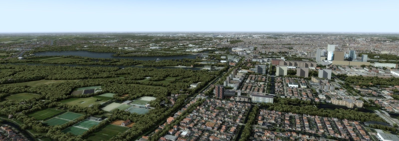
Now - again - the question is how this will look in the sim.
After a few more weeks, I had a test run for South Africa in the sim.
And that's how it looks now:
index.php


index.php


But unfortunately, there are some errors here as well.
So I have continued to work on my scripts and I hope that the next test run - this time for Kenya - will be better.

That's all for now. As soon as there are more news and pictures from the sim, I will of course show them to you!

Have a nice weekend everybody!
 
I've been watching your work for a while and I'm very impressed with it. Not everyone can handle geospatial data as well as you do. Your new 3-D lights give your scenery the finishing touches. I am full of admiration :)
 
Hi,

It looks gorgeous as always, just curious though. What country will it be next?

Kind regards, Erik
 
Hi Matthias,

Any chance I can get a download link for Switzerland? It looks stunning, can't wait to fly over the mountains.

Thanks and have a nice weekend!

/Erik
 
WOW, I haven't been following the showroom for a while, and your work just reminded me that I should. Great, excellent work, always have been a huge fan of photoscenery. Matthias, Is there any chance that you could do a few areas that are of interest to me as a developer? If you could PM me, I would love to have a conversation with you. Thanks, and take care!!
Bernardo.
 
I've put Portugal on hold due to the lack of data available.
Therefore, no download link is available.
 
Back
Top