• Which the release of FS2020 we see an explosition of activity on the forun and of course we are very happy to see this. But having all questions about FS2020 in one forum becomes a bit messy. So therefore we would like to ask you all to use the following guidelines when posting your questions:

    • Tag FS2020 specific questions with the MSFS2020 tag.
    • Questions about making 3D assets can be posted in the 3D asset design forum. Either post them in the subforum of the modelling tool you use or in the general forum if they are general.
    • Questions about aircraft design can be posted in the Aircraft design forum
    • Questions about airport design can be posted in the FS2020 airport design forum. Once airport development tools have been updated for FS2020 you can post tool speciifc questions in the subforums of those tools as well of course.
    • Questions about terrain design can be posted in the FS2020 terrain design forum.
    • Questions about SimConnect can be posted in the SimConnect forum.

    Any other question that is not specific to an aspect of development or tool can be posted in the General chat forum.

    By following these guidelines we make sure that the forums remain easy to read for everybody and also that the right people can find your post to answer it.

MSFS Drawing a Lake - Graphic Glitches

Messages
23
Country
austria
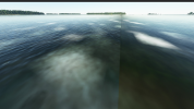
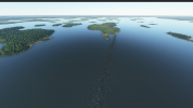
I have added a lake that was missing into MSFS by drawing a polygon and filling it with Water (LAKE).

I see glitches like below and despite redrawing the lake completely 3 times, they always reappear (alltough in different locations).

I have tried to fix it with terraforming, excludes, aprons. But that did not help. It seems the ground is coming up from below the water.

Could you please help with any more suggestions?
 

Attachments

  • 20201218105733_1.png
    20201218105733_1.png
    1.7 MB · Views: 173
  • 20201218105901_1.png
    20201218105901_1.png
    1.6 MB · Views: 154
  • 20201218105907_1.png
    20201218105907_1.png
    1.3 MB · Views: 160
Last edited:

rhumbaflappy

Administrator
Staff member
Resource contributor
Messages
5,945
Country
us-wisconsin
The lines seem to be roads and the white areas seem to be clouds. In the second picture, that seems to be an anomaly in color matching between aerial images.
I wonder if you could overlay an aerial image on the area to correct the color. We don't know how to delete the roads yet.
 
Messages
23
Country
austria
These white dots are all over the place, I believe they are either reflections or unsharpness in the original image. But I can get rid of them.

If that were roads how come they run perpendicular to each other across the lake (more like grid lines)? And different each time I draw the lake? Should not apron have a higher priority than road?

Ah yes, one more thing. If I put land there everything is fine, you cannot see any of the line when it’s an island or coast. It only appears on water.
 
Messages
290
Country
germany
I don't really know but I could imagine that when you draw land over the area a land texture is applied that cancels out the underlying imagery, while water maybe just overlays the original image which still shines through. Have you checked the original Bing image? Maybe the lake lies exactly where two different satellite image tiles meet with maybe different colors or resolution?
 
Messages
23
Country
austria
I have just found multiple locations where this happens in other places, too. But not all of my co flyers could see it. So, might be a setting as well ...
 
Messages
138
Country
poland
The lines are seamlines along certain QMID tiles. Trying to follow-up on this issue here:
 
Top