• Which the release of FS2020 we see an explosition of activity on the forun and of course we are very happy to see this. But having all questions about FS2020 in one forum becomes a bit messy. So therefore we would like to ask you all to use the following guidelines when posting your questions:

    • Tag FS2020 specific questions with the MSFS2020 tag.
    • Questions about making 3D assets can be posted in the 3D asset design forum. Either post them in the subforum of the modelling tool you use or in the general forum if they are general.
    • Questions about aircraft design can be posted in the Aircraft design forum
    • Questions about airport design can be posted in the FS2020 airport design forum. Once airport development tools have been updated for FS2020 you can post tool speciifc questions in the subforums of those tools as well of course.
    • Questions about terrain design can be posted in the FS2020 terrain design forum.
    • Questions about SimConnect can be posted in the SimConnect forum.

    Any other question that is not specific to an aspect of development or tool can be posted in the General chat forum.

    By following these guidelines we make sure that the forums remain easy to read for everybody and also that the right people can find your post to answer it.

FSXA Gmax Bacdrop from Sbuilder data

Messages
470
Country
unitedstates
I searched, and I am stumped...

I thought I read somewhere, that Arno had a way to create a reference/background in gmax/3dmax for design from an sbuilder geodata image....

I cant find it anywhere... Does someone know where that article/thread was?

Thanks in advance
 
I think I found what I was looking for...

http://www.fsdeveloper.com/wiki/index.php?title=Align_background_image_in_3D_editor

However, had to assign data using fwtools to the image, sbuilderx mentioned output of geotiff 'may have problems'... I didnt know how to fix this, so used fwtools to make a geotiff, worked (after typing in that long string, (be sure to check and double check syntax!!!)) then used the 'gdalinfo' command to extrapolate the center coordinates (i take it just doing an average in a calculator is incorrect; i tried and got different numbers than what you had in the example in the wiki, so...)

but, i wonder, how i can get a more accurate center, or rather a more resolute center, fwtools only outputs 7 decimal places rather then the 12 or 14 the other input coordinates use... just asking for more accurate coordinate...
 
Last edited:
Hi,
I read that Wiki and I think I'm so dump. I'm not quite understand this.
I'm writing about making google earth as a template of making scenery in Gmax.
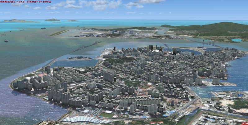
It is quite simple and I use it in quite a big area. After I compile the whole city of Macau to FSX, I think this method is easy and quite accurate. After I'm done with this tutorial, I'll tell you. In this picture, I use my method getting google earth to be a reference plane and make the whole city by this method. By MCX that correct the curvature of the earth, those buildings are exactly on the right place on photoscenery. The shadow you see is not from the model but from satellite photo.

NorthIsland.jpg


Tutorial will take a few days, since it is easy to make.
Best Regards,
Tic
 
Last edited:
could be my conexion, lately go crazy, but something happen with the page.
Anyway I see as the major problem the sitting of the buildings on the terrain, how can be solved to the building be adjusted to the sloped terrain.
Edit: it was my conexion, appreciate your work.
 
Last edited:
Back
Top