
• Which the release of FS2020 we see an explosition of activity on the forun and of course we are very happy to see this. But having all questions about FS2020 in one forum becomes a bit messy. So therefore we would like to ask you all to use the following guidelines when posting your questions:

    • Tag FS2020 specific questions with the MSFS2020 tag.
    • Questions about making 3D assets can be posted in the 3D asset design forum. Either post them in the subforum of the modelling tool you use or in the general forum if they are general.
    • Questions about aircraft design can be posted in the Aircraft design forum
    • Questions about airport design can be posted in the FS2020 airport design forum. Once airport development tools have been updated for FS2020 you can post tool speciifc questions in the subforums of those tools as well of course.
    • Questions about terrain design can be posted in the FS2020 terrain design forum.
    • Questions about SimConnect can be posted in the SimConnect forum.

    Any other question that is not specific to an aspect of development or tool can be posted in the General chat forum.

    By following these guidelines we make sure that the forums remain easy to read for everybody and also that the right people can find your post to answer it.

FSXA Ground Polygon Gaps. (Solved)

mendiola_loyola

Resource contributor
Messages
520
Country
peru
Dear all:

When I activate the option "Group Polygons 500 meter" I got cracked polygons like the picture.
I'm Using model converter X 1.4.0
Exported from 3ds Max 9 with the FSX SDK (3dmax9 scripts folder)

I think there are problems when the generated mdl comes from a X file generated from 3ds Max 9.
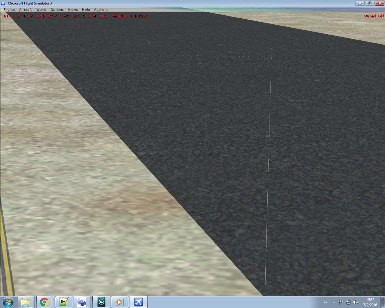
PolygonCracked.jpg


MCX140_Setup.jpg
Regards.
Alfredo Mendiola Loyola
Lima, Peru
 

Attachments

Are you sure you entered the correct altitude and that you have a flatten at the same altitude?
 
Are you sure you entered the correct altitude and that you have a flatten at the same altitude?
Yes Arno.
I have a flatten covering the polygon area, the flatten is set up to 30 meters.
I did a test using the Gmax with the FSX gamepack but the result is the same.

CrackedPolygon.jpg
 
So both in the GPW, in your flatten and in the airport elevation you have entered 30 meters as altitude? In that case you should not see a crack. But if any of the values is off, the correction for the curve of the earth can't be calculated correctly. That can give such cracks.
 
So both in the GPW, in your flatten and in the airport elevation you have entered 30 meters as altitude? In that case you should not see a crack. But if any of the values is off, the correction for the curve of the earth can't be calculated correctly. That can give such cracks.
Yes Arno, both the airport elevation and the flatten have 30 meter. The GPW is set up to 30 meters and the ADE file for the airport has 30 meters.

If you want I can send you the x, mdl ang bgl files.

Regards.
Alfredo
 
But the default airport is at 34.442 meters (like I said before)!!!!!!!!!
How did you change the altitude in ADE? Do you have a 'stub' in your scenery\world\scenery?
 
But the default airport is at 34.442 meters (like I said before)!!!!!!!!!
How did you change the altitude in ADE? Do you have a 'stub' in your scenery\world\scenery?
Are you saying there is a strong likelihood he never disabled the default airport, along with it's own flattens, likely at 34.442 meters? See, I'm not really sure because a) I can't tell what the default airport is because it's not in this thread and b) what does all your 34.xx2 meter stuff have to do with re-inventing the wheel anyway? It kind of looks like it might be funner to post questions and then figure out the answer one's self.

Alfredo should probably confirm the absence of mesh and conflicting scenery elements including flattens from other airports.
 
Are you saying there is a strong likelihood he never disabled the default airport, along with it's own flattens, likely at 34.442 meters? See, I'm not really sure because a) I can't tell what the default airport is because it's not in this thread and b) what does all your 34.xx2 meter stuff have to do with re-inventing the wheel anyway? It kind of looks like it might be funner to post questions and then figure out the answer one's self.

Alfredo should probably confirm the absence of mesh and conflicting scenery elements including flattens from other airports.

I disabled all my sceneries on FSX, I placed the ground polygon on the Addon Scenery folder.
I tested the ground polygon with the default airport elevation 34.442 meters and the result was the same.
It is hard to find the gaps on the polygon, there is one or two gaps on the polygon.
Even I created a bigger flatten polygon ...

Gap Coordinates on FSX:
12* 1.55'S
77* 6.72'W

MDL Setup:
Lat:-12.02220000
Lon:-77.11200000
Elev: 34.442

ICAO: SPIM
7-6-2016 8-37-01.png

Regards.
Alfredo Mendiola Loyola
Lima, Peru
 

Attachments

Awesome, thanks for the background information. For what it is worth I looked at your polygon in MCX and didn't find anything typical of the fractured poly your image shows. If I can, I'll explore further.

Please don't hesitate to be as descriptive and explicit as possible so it is easy to understand your situation, now and if someone searches this rhread. Thanks.
 
Ok I looked at you polygon again and it seemed perfect to me. I did not compile it but I would not suspect your 3d program, I would look to compilation or placement errors.
 
Dear Rick:
Did you see the Polygon on FSX?
Could you generate the bgl in your computer and share it to test in my FSX environment?

Regards
Alfredo Mendiola Loyola
 
When I import the generated bgl with the MCX 1.4 I can't see the complete polygon.
Only if I uncheck the group Polygons 500 meters I can see the complete polygons:

7-6-2016 23-16-11.png


Regards
Alfredo
 
Hi,

The mdl is at 10cm above the ground.
franja.jpg

The picture you show is a bgl that probably contains two mdl's. Click on the green arrow to see the other one.
Make sure they are both at 0.00m using the move button. Then merge the second one to the first one and export the merged mdl.
Open the merged mdl with the GPW and convert.
 
I have not had the opportunity to compile, but in MCX I see a perfect rectangle composed of 80 polygons with 161 sides which is exactly what I would expect and it is a single model.
 
I needed to set the model at -0.1m for it to display correctly at the runway mid-point. However, it is slightly higher at the ends.

I see no breaks in the texture:

 
I disabled all my sceneries on FSX, I placed the ground polygon on the Addon Scenery folder.
Some addon files do not reside within the Addon Scenery folder and it very much appears to me that you have other scenery elements interfering with your tests. If you are testing for your own use exclusively, then it is good to discover what causes this issue and correct this scenery for it. If you are testing for distribution, then you should locate the unique factor in your individual system and eliminate it.
 
Could you generate and attach a bgl file from the mdl attached to test it on my computer?

Regards
 
Here come the bgl and the mdl (because I do not have your texture). I had done the same as George in MCX (= lower the model 0.1 m z) first.
 

Attachments

Back
Top
