• Which the release of FS2020 we see an explosition of activity on the forun and of course we are very happy to see this. But having all questions about FS2020 in one forum becomes a bit messy. So therefore we would like to ask you all to use the following guidelines when posting your questions:

    • Tag FS2020 specific questions with the MSFS2020 tag.
    • Questions about making 3D assets can be posted in the 3D asset design forum. Either post them in the subforum of the modelling tool you use or in the general forum if they are general.
    • Questions about aircraft design can be posted in the Aircraft design forum
    • Questions about airport design can be posted in the FS2020 airport design forum. Once airport development tools have been updated for FS2020 you can post tool speciifc questions in the subforums of those tools as well of course.
    • Questions about terrain design can be posted in the FS2020 terrain design forum.
    • Questions about SimConnect can be posted in the SimConnect forum.

    Any other question that is not specific to an aspect of development or tool can be posted in the General chat forum.

    By following these guidelines we make sure that the forums remain easy to read for everybody and also that the right people can find your post to answer it.

I need assistance adding an apron

Messages
1,839
Country
australia
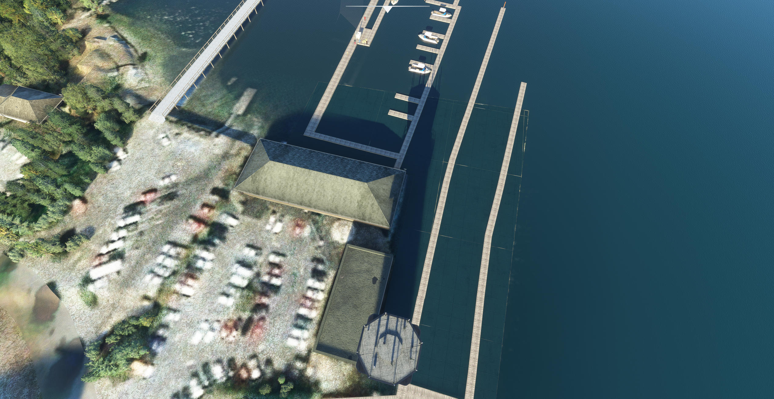
To remove satellite (ghost) images of boats in the water at my water airport I have added an (polygon) APRON and almost matched the color to the color of the surrounding water by a lot of trial and error adjusting the RGB values.
Problem is that TILING is evident even though I tried using a tiling (distance) of both 0 (meters) and 1000 (meters) PLUS there is a distinct edge to the area.
What parameters need 'tweaking' to remove this. I just want to remove all tiling.
Here is an image showing what I mean.

apron.jpg
 
Have you thought about taking an aerial overhead shot of what exists (Bing), making your edits there to clear things out, and feathering to 0 alpha (full transparency on the edges) - then layering that overtop as your material?

Riffing off of the top of my head here - there could be downsides to that - I'm vaguely remembering that water is complicated.
 
Thanks for the suggestion.

I have just noticed that the SURFACE type is set to CONCRETE which would probably explain the tiling.

When I used Airport Design Editor for a different project and also to remove 'ghost' satellite images of boats where there was no tiling the surface type was WATER. Problem is that in DevMode I cannot work out how to change the surface type to water and when I select/click on the surface type it changes to navigating to where a surface type image might be stored.

Any ideas how to set or change the surface type to water would be appreciated.
 
Any ideas how to set or change the surface type to water would be appreciated.
The attribute is in the object properties panel. If you cannot find it, then you can just edit the airport XML manually to change the surface types. You will have trouble matching polygon color to nature, because polygons can be only the one color you define and nature has variety.
Have you thought about taking an aerial overhead shot of what exists (Bing), making your edits there to clear things out, and feathering to 0 alpha (full transparency on the edges) - then layering that overtop as your material?

Riffing off of the top of my head here - there could be downsides to that - I'm vaguely remembering that water is complicated.
It looks like you are commenting about creating a custom CGL. That would be the best way to accomplish what is intended. Also, a projected mesh would work, projected meshes are like ground markings you can just throw down and be done with it.
______________

I had nearly the opposite problem for a tropical island scenery I'd developed. Sub surface CGL is suppressed in much of the world using water masks and a recent update included much touted improvements to the water masking in some popular tropical areas. Underwater reefs are some of the most beautiful aerial imagery I know of and I wasn't going to wait for Asobo to activate mine.

Adding a water polygon over the entire area revealed the underwater colors, it also turned ocean into land, it added grass to the surface which I immediately labeled "kelp," stilled the waves and depressed the surface about 7 feet. Then I added a terraform poly to raise the surface back up, because water poly's won't terraform. As to the water becoming "ground," it was not an issue, because the islands occupants had bored a channel through the reef for my AI ships to navigate.

The Subi.jpg
traffic.jpg


I strongly endorse Jon explore CGL creation, they can be edited easily and also explore Projected Meshes, which are very similar to CGL, but they can be placed and moved.
 
Thanks Rick - that was the idea (projected mesh) on a polygon. But to your point, he could just do a CGL. I've only done it around land and don't know how easy those water masks are to do now with the improvements to the SDK.

When I used Airport Design Editor for a different project and also to remove 'ghost' satellite images of boats where there was no tiling the surface type was WATER. Problem is that in DevMode I cannot work out how to change the surface type to water and when I select/click on the surface type it changes to navigating to where a surface type image might be stored.

This is bringing up some questions for me personally - I almost always use aprons for all of my ground texturing and I'm unclear when/why you would use a polygon for textures instead of an apron (I typically use polygons for vegetation, removing TIN, terraforming, etc.).

If it's an apron, you just select the polygon in dev mode and change the texture that's on it. Sounds like it has the default concrete texture, so you would drag and drop one of Asobo's default water textures from the material list into the texture slot on that apron.

Here's a tutorial on how to do this with a polygon (not an apron) - but you do the same thing with your apron by typing in 'water' in the filter, finding one you like and dragging and dropping it onto the blue "texture" button on your apron.

Here's a tutorial on adding or removing water with polygons (not sure if that'll actually help with your situation) - so that's a polygon instead of an apron.

Doing a custom CGL is a process if you haven't done it before (and can be finicky), so I would leave that option for last if not. The whole needing to add masking to the water areas its its own thing on top of the CGL creation process.


Good luck!
 
Thanks Rick - that was the idea (projected mesh) on a polygon. But to your point, he could just do a CGL. I've only done it around land and don't know how easy those water masks are to do now with the improvements to the SDK.
Custom CGL does not involve water masks. Defining terrain as water is not part of CGL functionality. Think of CGL as "paint markings."

This is bringing up some questions for me personally - I almost always use aprons for all of my ground texturing and I'm unclear when/why you would use a polygon for textures instead of an apron

Aprons are for airports, polygons are for everywhere else. I find aprons to be easier to configure and less universally applicable as aprons and everything polygons and aprons do, can be swapped in the airport XML. Simply replace "apron" with "polygon" and vice versa and all will work, unless there is not a runway near enough to enable "apron mode."

Doing a custom CGL is a process if you haven't done it before (and can be finicky), so I would leave that option for last if not. The whole needing to add masking to the water areas its its own thing on top of the CGL creation process.
A CGL is only visual, it does not change ground polygon attributes. If a body of water displays static boats, they are already in "water." If that same location has it's default photo ground replaced with custom, the boats will be gone, or changed to seahorses, or whatever Jon fancies and that is all that changes. Water masking is as relevant after, as it had been before, CGL has no effect on that.

As to "finickiness," you leave it unclear where you draw the line. IMO, you are either going to simulate, or you are going to play someone else's simulation. My line, is that I have tried many techniques to accomplish exactly this, from removing static waves, clouds and yes, even ships, from my ground imagery and most techniques fall short. To me, that is finicky.
 
Thanks for some clarity on the apron vs. polygon. Aprons have definitely been working just fine for all of my general texturing purposes so far.

My line, is that I have tried many techniques to accomplish exactly this, from removing static waves, clouds and yes, even ships, from my ground imagery and most techniques fall short. To me, that is finicky.

Agreed on that. I've only been using CGLs directly around the airport area to clean everything up - everything hinges on the original aerial shots as a poor base creates a tooon of work in photoshop for me.

Thanks for more details on masking - just haven't had to play with it yet so I'm pretty ignorant to how it works.
 
Thanks shadeobrady and Rick

I will leave CGLs (can't remember reading or hearing about them before) to another day. I will make a note to (try to) learn about them.
I am using an apron to hide those 'ghost images' from (AFAIK) satellite imagery overlays as it seems to be the only method to do that (would be great if Asobo ever set up an exclude parameter for polygons to exclude satellite imagery overlays - I have seen a YouTube tutorial showing how to remove a 'ghost image' of an aircraft next to a runway but can't remember where it is to watch it again.

Yes I looked up the SDK documentation (after my post - sorry) of Aprons and Surface type and see the reason for my problem there - I have to forget about how ADE works and concentrate of how DevMode works (and a little less Christmas 'spirit' :D )
 
Last edited:
Ok I have had some success with my water apron which has eliminated all those ghost boats and thankfully I got the color of the water to match areas outside the apron polygon (see first image of how it looked before my water apron) HOWEVER there remains a strange area on the water with distinct straight sides which is a lighter color than the surrounding water even though I made the apron polygon large enough to cover that area (see second image below after I added the water apron and adjusted the color - I didn't cover the boats in the area to the far left though). I thought that it could be caused by reflections so used the 'weather gadget' to change the time of day to be mid summer and changed the time of day from early morning through mid day to later afternoon and that area did not change.
It's only a 'bug bear' to me but though I would ask the question of people much more learned and gifted than me what they think it could be.

ghost_satellite.jpg


ghost_strange.jpg
 
Thanks for that.
I will probably 'publish' my water airport with the water apron as it looKs reasonable and maybe once I get "the hang of" CGLs attempt to improve it and update an updated version.
Thanks again
 
Last edited:
The line is where two different satellite photos intersect.
 
Thanks Rick. It is more than a line though more like a polygon. Anyway there it will remain.
 
Here is the tutorial I use for CGLs essentially - start to finish! Take a bit to get through at first but after a few tries it becomes pretty simple.
I have watched that video and I firstly must say is that I used something very similar for my water airport in FSX to get the water depth look correct (shallow water showing almost like sand and deeper water having a darker image).
Looking at the current Google satellite image I'm not sure if I can use it as the satellite image must have been taken when there were waves on the water with sunlight shining on the wave crests.
Here is an example to illustrate what I mean. Maybe I could 'clean it up' with an image editor but at this time I couldn't be bothered. These problems (sunlight reflections) would probably not be a problem when using satellite imagery of land.

water.jpg
 
I have watched that video and I firstly must say is that I used something very similar for my water airport in FSX to get the water depth look correct (shallow water showing almost like sand and deeper water having a darker image).
Looking at the current Google satellite image I'm not sure if I can use it as the satellite image must have been taken when there were waves on the water with sunlight shining on the wave crests.
Here is an example to illustrate what I mean. Maybe I could 'clean it up' with an image editor but at this time I couldn't be bothered. These problems (sunlight reflections) would probably not be a problem when using satellite imagery of land.

View attachment 85665


Not sure if it's an option, but if you use the Google Earth desktop app, there's a 'history' button at the top that lets you go backwards through all of their shots. Really depends on how it lines up with what you see and can work with. If you get a good shot of the water in one of them, even if the land area looks poor, you could plop that over, add some alpha/opacity feathering on the edges to help blend, and use that as the shot.

google-earth.jpg
 
Thanks for that info. I looked for an option to change time of day and didn't see one. I will check out the history button. The only problem I foresee is that the bay contains docks and boats which I have created in part with my own docks and boats. I might need to 'remove' them from the image using an image editor. I am trying to find what I used when I developed the water airport for FSX using Airport Design Editor and also SBX as I remember clearly recreating the effect of shallow water around the foreshores using a satellite image.
 
Thanks for that info. I looked for an option to change time of day and didn't see one. I will check out the history button. The only problem I foresee is that the bay contains docks and boats which I have created in part with my own docks and boats. I might need to 'remove' them from the image using an image editor. I am trying to find what I used when I developed the water airport for FSX using Airport Design Editor and also SBX as I remember clearly recreating the effect of shallow water around the foreshores using a satellite image.

Yeah - Google Earth Pro's history slider only goes back step by step along the times they took imagery of the area that it deemed 'okay enough' to catalogue. Should be daytime, but may not be a specific time of day you want. Could be cloudy, could be blurry, etc. Usually the imagery of the area you would see on the website (Google Maps) isn't necessarily the 'most recent' shots they've taken that you can see on Google Earth. It's a bit of a game unfortunately.

You will almost absolutely have to remove the boats in the aerial imagery in image editing software. Water aside, I've spent at least a couple hours editing out tons of stuff from my aerial CGLs in photoshop, and I'm fairly quick with a background in it - it can take some time.
 
I agree. I usually use the CLONE tool to remove unwanted things from any image. That way you replace the object (boat etc) with exactly the same color/texture as next to it.
 
Not sure if it's an option, but if you use the Google Earth desktop app, there's a 'history' button at the top that lets you go backwards through all of their shots.
Google Earth is a browser, it does not provide satellite imagery, it provides images that have been derived from satellite imagery and beyond screen grabs, users have no access to historical imagery and at any rate, none of the imagery provided by Google Earth has been "georeferenced."

"Georeferencing," is what Jon does when he writes down the numbers near the corners of his screen grabs and uses those to position his captures. There is dedicated software that does this automatically and I am sure you saw a name like "QGIS," or "OSGeo4W" in the tutorial video. These cartographer level mapping tools also work as excellent browsers, if one can forego the hyperlinks and embedded panoramas. The software is no more, or less difficult to use, than Google Earth itself, with the additional support of dedicated instructional videos and help forums, as compared to scrolling in on the screen using one's bifocals.

It is understandable that people may not want to trouble themselves to "figure things out," as much as they may not want to trouble themselves to learn a new technique, all good. I can tell you I myself spent years reading this forum, waiting for other peoples' problems to pop up so I could figure out my own, before I ever had the courage to make my own first post, a bit shy, I suppose and it is for those silent thousands, as well as the current participants, that I provide these clarifications.

In terms of visually verifiable quality and given the illegality of distributing derivatives, Google Earth is the absolute worst place from which to obtain satellite imagery, imo.

 
In terms of visually verifiable quality and given the illegality of distributing derivatives, Google Earth is the absolute worst place from which to obtain satellite imagery, imo.

While I appreciate the larger range of experience you have, it would be more helpful to actually provide those links specifically. I know for the region I'm currently working on that I've looked through all sorts of imagery from local government scans to some private samples made feely available, and in the end - it's down to mostly Bing and Google, the latter providing imagery that is far superior, but needs immense correction in image editing software.

I'm simply offering a toe in the water here.
 
Back
Top