• Which the release of FS2020 we see an explosition of activity on the forun and of course we are very happy to see this. But having all questions about FS2020 in one forum becomes a bit messy. So therefore we would like to ask you all to use the following guidelines when posting your questions:

    • Tag FS2020 specific questions with the MSFS2020 tag.
    • Questions about making 3D assets can be posted in the 3D asset design forum. Either post them in the subforum of the modelling tool you use or in the general forum if they are general.
    • Questions about aircraft design can be posted in the Aircraft design forum
    • Questions about airport design can be posted in the FS2020 airport design forum. Once airport development tools have been updated for FS2020 you can post tool speciifc questions in the subforums of those tools as well of course.
    • Questions about terrain design can be posted in the FS2020 terrain design forum.
    • Questions about SimConnect can be posted in the SimConnect forum.

    Any other question that is not specific to an aspect of development or tool can be posted in the General chat forum.

    By following these guidelines we make sure that the forums remain easy to read for everybody and also that the right people can find your post to answer it.

FSX Meshing around with SBuilderX

Hi Emilio:

I'm not certain what resolution ASTER DEM ollyau accessed to make his sample mesh BGL at the link above, but I'm glad he so kindly contributed to the discussion and exploration of the scenery building process for your project area. ;)


If you are still interested in further working through your own FSX SDK terrain mesh creation process, I have attached an ASTER DEM which I had access to via Global Mapper (while still trying to locate my login ID info for the main ASTER DEM site).

[EDITED]

FYI: The download WMS source declared the data to be "tiled only, 1.5 arc-second per pixel"; IIUC, the resulting FSX Terrain SDK "Resample" elevation mesh output should appear more detailed than would have been possible using only the 90 Meter SRTM DEM data.


http://www.mapmatters.org/wms/588904

"Layer Abstract

Subsampled version of the ASTER Global Digital Elevation Map (GDEM). Details are available at http://asterweb.jpl.nasa.gov/gdem.asp. Redistribution of the full resolution original data is not allowed, this dataset is subsampled to 1/2400 pixels per degree (1.5 arc-sec, 45m). Tiles, described by the http://onearth.jpl.nasa.gov/wms.cgi?request=GetTileService, are 16bit PNG files, where the 16 bit values should be interpreted as signed short integers, in meters.
"


http://asterweb.jpl.nasa.gov/gdem.asp

"The GDEM was created by stereo-correlating the 1.3 million scene ASTER VNIR archive, covering the Earth�s land surface between 83N and 83S latitudes. The GDEM is produced with 30 meter (elevation data point) postings, and is formatted in 1 x 1 degree tiles as GeoTIFF files. Each GDEM file is accompanied by a Quality Assessment file, either giving the number of ASTER scenes used to calculate a pixel�s value, or indicating the source of external DEM data used to fill the ASTER voids."


The attached ZIP file includes source data exported via Global Mapper "projected" as a Geographic Projection (Lat-Lon) with WGS84 Datum GeoTIFF (aka fully geo-rectified *.TIF) file format with accompanying *.TFW (and optional *.PRJ file for use in other GIS software) as would be needed for terrain mesh creation via FSX SDK Resample.

CAVEAT
: Do not open the original *.TIF as an image in a graphics app and save back into that same original file... or you will lose the internal geo-rectification info; only work with a copy of that file for purposes other than processing by FSX Resample.

[END_EDIT]

Because the DEM is in GeoTIFF format, you would only need a simple *.INF file to process the data via FSX SDK Resample; perhaps Dick (aka "Rhumbaflappy") and/or others here might wish to participate as well... by explaining the statements required by an "INF file" for the data I attached below.


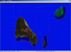
BTW: The area covered for this sample DEM is shown below and described in the Metadata file; a "closeup" shows that Taboga Island is centered in the DEM.


Hope this helps ! :)

GaryGB
 

Attachments

  • Tobago Panama ASTER DEM Sample.jpg
    Tobago Panama ASTER DEM Sample.jpg
    57.8 KB · Views: 708
  • Taboga_Panama_tif_tfw_prj_Metadata_txt.zip
    Taboga_Panama_tif_tfw_prj_Metadata_txt.zip
    389.8 KB · Views: 478
  • Tobago Panama ASTER DEM Sample_Closeup.jpg
    Tobago Panama ASTER DEM Sample_Closeup.jpg
    34.8 KB · Views: 805
Last edited:
Thanks to all that have cooperated into this thread to resolve the mesh problem I was having with this island. Though the mesh part is still kind of a mystery to me, I am VERY glad to finally see this island in a way that more closely approximates reality!

Things to observe are that the lower part near beach shows 0 altitude instead of 2-3 meters but I can live with that. Also, there is a peak in Uraba island (just off Taboga) which is not as acute but then again, I can live with that as well. I don't know why I am getting those blue contours and blue spots in the sea area where the photoreal tile had either the silhoute of a small vessel or in the contour of the island. I had used a watermask and a simple blend mask to obliterate the water background of the photoreal tile. Any idea how to get rid of those blue spots?

For those interested in perhaps flying in this area :-) here is a link to the current state of the island. Not perfect but much better than the default. Points I have to improve upon:

  • Getting rid of the blue spots and blue contours
  • Replacing the default Marina with a custom scenery object
  • Replacing the fishery port with a custom scenery object
  • Making the silos bigger
  • Make the road in Taboga usable for a small vehicle. There are no cars in the island other than a few golf carts
  • Adding more autogen trees
  • Creating autogen houses for the town
  • Perhaps creating the boardwalk as a custom scenery object
  • Custom scenery object for the historical church

Notice that from the island you get a nice view of Panama city as well :-) Naturally, the real life skyline is much more impressive.

Airports in the vicinity: MPHO (nowadays MPPA but FSX is outdated), MPMG and MPTO.
 
Hi Emilio:
If you are still interested in further working through your own FSX SDK terrain mesh creation process, I have attached an ASTER DEM which I had access to via Global Mapper (while still trying to locate my login ID info for the main ASTER DEM site).
GaryGB

Hi Gary,
Thanks, as I understand this ZIP is restricted uniquely to the depicted area, right? It would indeed resolve many of the current eye sores (lack of elevations) of default scenery of Panama city, in particular MPHO and MPMG which are covered by your tile.

From this GeoTiff I can generate a DEM BGL as Ollyau did with the resample I guess (???, need to reread material). Sorry if the question seems too dumb from this meshed down user :-)
 
Here's a copy of a PM I sent to Emilio regarding the DEM, for anyone interested. Perhaps it'll help someone else learn something new.

ollyau said:
lordofwings said:
Hello there!
Thanks a lot for the DEM you posted on the "Meshing around with SBuilderX" thread I started. Though not perfect (it has some peaks) it is much better than the default (and even FSX Mesh SA).

I was wondering, this DEM BGL is for the entire
country of Panama or just the Taboga area? which
lat/lon boundaries you used? and may I know what is the mesh resolution?

Do you know of a short stepwise tutorial to create the DEM BGL from an ASTER DEM?

Regards,
Emilio
Hey Emilio,

You're welcome. :)

The BGL was created from the 30 meter resolution data available from the ASTER Global Digital Elevation Model (GDEM) product available from NASA and Japan's METI (Ministry of Economy, Trade and industry). I simply used FWTools to reproject the GeoTIFF I downloaded, then ran the resulting GeoTIFF through the FSX SDK Resample tool to create a BGL. The resulting scenery turned out to be LOD10, which equates to about 38 meters/pixel in FSX.

I think it covers approximately N09 (lat) W080 (lon) to N08 (lat) W079 (lon). You can view the BGL in the Tmfviewer FSX SDK tool to get an idea of the more precise extent. For convenience, I've embedded a screenshot:

HqWmC.png


Lastly, here are a few relevant links if you're interested in making some mesh yourself:

ASTER GDEM: http://asterweb.jpl.nasa.gov/gdem.asp
FSDeveloper Wiki: http://www.fsdeveloper.com/wiki/index.php?title=GeoTIFF_file_creation_with_FwTools
Resample tool SDK: http://msdn.microsoft.com/en-us/library/cc707102.aspx#TheResampleTool

Hope this helps,
Orion
 
Hi Gary,
Thanks, as I understand this ZIP is restricted uniquely to the depicted area, right? It would indeed resolve many of the current eye sores (lack of elevations) of default scenery of Panama city, in particular MPHO and MPMG which are covered by your tile.
The GeoTiff in my attached ZIP above was downloaded into Global Mapper via its "WMS" connection feature (I use version 12.x). :idea:

The resulting GeoTiff layer was the result of requesting data for an area 10 miles surrounding the center of Taboga Island.

The larger screenie I posted above shows the area included in the requested 10 mile area; for the "closeup" screenie I had arbitrarily zoomed to the area around Taboga Island:

http://www.fsdeveloper.com/forum/showpost.php?p=227562&postcount=21


IIUC, the tile that ollyau downloaded would likely have been derived from one of the "1 Degree-x-1 Degree Tiles" accessed via the main ASTER DEM distribution site based on his screenie:

http://www.fsdeveloper.com/forum/showpost.php?p=228028&postcount=24


FYI: In Global Mapper (and many other GIS applications), one can "merge" multiple GeoTiff DEM tiles such as those discussed above, then output in "grid sets" as GeoTiff DEM files custom-sized to fit into the FSX terrain "quad matrix" tile system at various Levels Of Detail (aka "LODs").

Those GeoTiff DEM files can then be used to create working sets of mesh source files referenced in 1 or more *.INF files and/or *.INF file [Source] sections... that can be processed by FSX SDK Resample without crashing... to output 1 or more terrain mesh BGL file(s).


From this GeoTiff I can generate a DEM BGL as Ollyau did with the resample I guess (???, need to reread material).

Yes, that data is a 16-bit GeoTiff; one can also use a 32-bit GeoTiff as source data for FSX SDK Resample.

The *.INF file for GeoTiffs as input source data is among the simplest to structure for use with Resample.


BTW: To assist with the learning curve (since the FS SDK is often incompletely undocumented for many of its features), "Search" at FSDeveloper and AVSIM forums, as well as via Google for these query keywords (separated by spaces and without quotes):

"FSX GeoTiff resample INF"


PS:
Things to observe are that the lower part near beach shows 0 altitude instead of 2-3 meters but I can live with that.

Also, there is a peak in Uraba island (just off Taboga) which is not as acute but then again, I can live with that as well.

Since IMHO, the use of ASTER GDEM data will become increasingly important to some FS Developers for parts of the globe where other data is unavailable (and/or unaffordable) as an alternative to the lower resolution SRTM data, I am researching currently available methods using freeware applications which may be used to directly edit terrain elevations in DEM source files for scenery areas that merit correction and/or enhancement to make the most of what ASTER GDEMs currently offer for use in the FS world. :wizard:

Hopefully I'll have additional info for you on those options as early as Tuesday or Wednesday of this week. ;)


Hope this helps ! :)

GaryGB
 
Last edited:
Hi Emilio:

I took a look at the package you posted above for your Taboga area Work In Progress (aka "W.I.P."), and I see it is indeed an interesting location that could be developed into a rather nice add-on for FSX ! :cool:

http://www.fsdeveloper.com/forum/showpost.php?p=227985&postcount=22


After initial analysis of the project area and available source data, and before deciding what, if any, processing of the GDEM source data might be needed external to FSX SDK Resample for that project area, I wanted to first inquire as to whether you will be posting for inspection another updated package (...or additional files needed for that package such as the "exclude file" you referenced in this thread):

http://www.fsdeveloper.com/forum/showthread.php?t=79635


When loaded on my FSX system, the default scenery is also displayed from beneath your project files; this may obfuscate proper interpretation of the elevation mesh and land class tile configuration for that area. :o


NOTE: This cannot be seen in TMFViewer when inspecting your project files unless one also loads the local FSX default files for Taboga Island area: ;)

(TMFViewer is located at: [FSX SDK install path]\SDK\Environment Kit\Terrain SDK\TmfViewer.exe)

  • [FSX install path]\Scenery\0303\scenery\dem0303.bgl
  • [FSX install path]\Scenery\0303\scenery\cvx2628.bgl

...in addition to your own W.I.P. project files:

  • [FSX install path]\Addon Scenery\PA-Taboga\Scenery\ASTGTM_N08W080_dem_wgs84.bgl
  • [FSX install path]\Addon Scenery\PA-Taboga\Scenery\cvxPA-Taboga.BGL
  • [FSX install path]\Addon Scenery\PA-Taboga\Scenery\PhotoTaboga.BGL


FYI: Once all the above files are loaded in TMFViewer, one can 'check' or 'un-check' those files from the TMFViewer "View" pull-down menu to analyze the local FSX terrain loading scenario


Thus, I would await your reply before proceeding further with my analysis of what may or may not be needed as far as any special processing of the GDEM data for use in making FSX terrain mesh for your project location. :)


PS: I've posted screenies below for illustrative purposes.


GaryGB
 

Attachments

  • Taboga Island Panama_Custom_and_Default-FSX.jpg
    Taboga Island Panama_Custom_and_Default-FSX.jpg
    97.4 KB · Views: 879
  • Taboga Island Panama_Custom_and_Default-TMFViewer.jpg
    Taboga Island Panama_Custom_and_Default-TMFViewer.jpg
    87.9 KB · Views: 712
Last edited:
Hi GaryGB thanks for the information, the area is indeed full of potential, not only Taboga but also the so called Causeway with the three joined islands at the Pacific entrance of the Panama Canal. Been working on that but got sidetracked with other easier mini projects.

As for Taboga I need to get rid of the default islands that still show up. I put the photoreal but didn't do the exclude all, water poly, hole, island contour thing. That is why it still shows. I haven't figured out how to get rid of the BLUE line on the contours of the island, have no idea where it comes from.

So, what is it that you require for TBG? I understood you wanted to massage the DEM so that the beach & town doesn't show at water level, right? the beach itself has a slight slope and the walking area along the beach is about 2 meters high.

Will try to do some work on it today, been busy with non-FS stuff lately :(
 
Hi Emilio:

It's a good idea to take things a step at a time, and to work with easier tasks initially, so one goes from success to success. :twocents:


Doing "islands" is certainly one of the more challenging FS scenery creation tasks, especially when adding a photoreal imagery custom land class texture with Blend Masks into the mix. :o


BTW: Perhaps resolving the artifacts involving the blue "halo" around the 'white' boats might be made easier with review of some of the info and links in these thread: ? :idea:

http://www.fsdeveloper.com/forum/showthread.php?p=231569#post231569

http://www.fsdeveloper.com/forum/showpost.php?p=222135&postcount=3


Regarding the elevations being rendered by FSX at run-time when it loads both your set of files and the default files listed above for your project in its current state (WITHOUT the "exclude all, water poly, hole, island contour thing"), I believe it is best to defer my analysis of elevations until after the default scenery has been fully and properly excluded... so I don't mis-interpret any "bad altitudes", thereby causing some "bad attitudes". :D


The reason for that would be, when those default files for Taboga Island still load in combination with your own new files and a 3rd party terrain mesh file, one may not get a correct interpretation of what the FSX rendering engine will ultimately display for elevations.

It may be that after the default scenery is excluded etc., the GDEMs can already be used 'as is' to fix the current "perceived" elevation issues you are reporting along the Taboga and nearby island coastlines (these elevation issues may not be present after the total island scenery configuration is fixed and default scenery is excluded). ;)


So, feel free to let me know when you have successfully implemented the "exclude all, water poly, hole, island contour thing"; then I'll see what, if any, processing of the GDEM source data might be needed 'external' to FSX SDK Resample for that project area.


If you wanted to further refine the GDEMs for greater accuracy to fix objectionable peaks and valleys which don't exist in the 'real world' of your project area (a known issue with ASTER data), and/or if you wanted to ensure that the properly depicted real world peaks (ex: Taboga's 307 Meter max elevation) were set at their correct real world elevations MSL, some pre-processing of the GDEM source data would be needed 'external' to FSX SDK Resample.


After your Island is otherwise completely finished with the default scenery excluded, I could offer some information on how the GDEM source data for your project area could be edited for greater accuracy with real world elevations; this would be done 'external' to (and prior to processing into terrain mesh BGLs by...) FSX SDK Resample.

I believe that, when you're ready, it should be OK for you to proceed to 'completion' of Taboga and other nearby island coastlines using the current GDEM-derived terrain mesh BGL you have from "ollyau", as the mesh-clinging vector content (including the photoreal imagery) BGLs should drape properly on any subsequent terrain mesh BGL made from an "edited" copy of that same GDEM source data.


Hope this helps ! :)

GaryGB
 
Last edited:
Do SBuilderX excludes work differently? I don't think so but whenever I did an Exclude All polygon in FSX KML I remember a whole large square landmass appeared where water was (kind of a profetical thing). This landmass then had to be refilled with water and then blast a hole into it.

I intend to do the same here in the TBG project. I put a large exclusion polygon that covered all three islands (Taboga, Taboguilla, Uraba) and marked it with the Exclude ALL flag. Recompiled the exclusion with the "Copy to FSX folder" as I have been using so far.

The problem is -and the reason why I ask- that I don't see that square landmass appearing, the photoreal islands show with surrounding water. Am I missing some SBuilderX exclusion trick?

Also, I don't see any Polygon Hole attribute in the Polygon properties so I simply contoured one island (so far) with a poly of 1008 points (pfew!) and tagged it as LC Mixed Forest. Is that the proper SBuilderX way? Is there also a way to "copy" a polygon so that I don't have to draw it again (for example to tag it as shoreline)?
 
Last edited:
Hi Emilio:

In addition to threads you had personally participated in previously, there are a number of other threads with tutorials which endeavor to better explain the creation of "islands" using SBuilderX.


A quick FS Developer search found these (some with external links too):


http://www.fsdeveloper.com/forum/showthread.php?t=15598&highlight=SBuilderX+island


http://www.ptsim.com/forum/viewtopic.php?f=22&t=1629


http://www.fsdeveloper.com/forum/showpost.php?p=129469&postcount=26


http://www.fsdeveloper.com/forum/showthread.php?t=19674&highlight=SBuilderX+island


BTW: Just in case you need this for some future scenery project to derive coastlines when "obscured by clouds" in imagery:

http://www.fsdeveloper.com/forum/showthread.php?t=19969&highlight=SBuilderX+island


Hope these 'leads' might help ! :)

GaryGB
 
Last edited:
Thanks for the other references Gary, checked them out and got some important information out of them. However, I am still stumped with the exclude.

On the 1st figure (SBX - Exclude Details) you see that I created an exclude polygon which I flagged "Exclude ALL". Then the top right island I made a contour along its coastline and set it landclass "Tropical Forest" (though the photoreal will override that). I then marked it as Polygon Hole and managed to select the upper QMID11 polygon as its parent (the "perforated" poly).

Likewise, because the upper QMID11 floods a great part of the city as well I created a polygon to recreate the coastline (closed poly). I marked it Landclass Tropical Forest (no photoreal there) and then marked it with "Set as Hole". I also managed to select the same upper QMID11 polygon as its parent, that's why it is showing as white.

I recompiled and deployed and am puzzled that it doesn't seem to work anyway. As you can see in the 2nd (FSX - Exclude Broken) image part of the mainland is still FLOODED in spite of the polygon hole with landclass. And even though my exclude is flagged "Exclude ALL" the contours of the default mainland shoreline are still very visible.

I had to add another Exclusion polygon on the upper part of the upper QMID11 and marked it only Exclude Shorelines. Now the default shorelines don't show. Don't know what else I did :/ that the landclass is now showing on one side but on the other it refuses to select a Parent Poly. This program has an attitude :(.

AFAIK I am doing everything right, first exclude All, then a hydro expanded to two (island crosses a QMID11 boundary) QMID11 HYDRO polygons, created landmass polygon, "punched it" (set as hole) and selected the corresponding QMID11 hydro polygon as the parent (perforated poly).
 

Attachments

  • FSDev-ExcludeDetails.jpg
    FSDev-ExcludeDetails.jpg
    32.6 KB · Views: 651
  • FSDev-SBX-ExcludeBroken.jpg
    FSDev-SBX-ExcludeBroken.jpg
    37.2 KB · Views: 679
Last edited:
Just posted an update with the current situation (A02):

http://www.mediafire.com/?467o3vwwvr5d7ap

I added a new photo tile North of Taboga consisting of 3 joined islands (causeway) I noticed that without photo and just a land/hole thing, FSX would not display the causeway, perhaps it expects a minimum with for it to be visible. So I decided to better add a photo tile. The last two islands have a hill in them though they appear flat on FSX :(

The area of this photo tile is covered by the ASTER DEM. However, I don't know what is happening now, if you load it in FSX you will notice that the blue flurries are still there (can't figure out how to correct the mask/blend for it to go away) and worse yet, in spite of the ASTER DEM BGL present there, now Taboga has been flattened. I have no idea why. Can somebody confirm?
 
Hi Emilio:

Since you thus far are using Google Earth imagery tiles as source data for your photoreal custom land class textures, you would not be able to utilize the project in that form as a commercial product without first licensing the aerial imagery, so I assume this project is intended for either personal use or as a freeware offering to a select group of friends in a non-public (registration required... but FREE membership) online environment (ex: a "VA"). ;)


So, IMHO, I don't see why you might not be willing to simply post as an attachment, the local SBuilderX project (ex: Taboga) as an exported SBX file. :confused:

Thus far, you are only posting the output BGL files... which still leaves important parts of the development process inaccessible for analysis and suggestions. :rolleyes:


Based on what I have seen with previous forum posters describing such complex and baffling scenarios in written form, I believe that it would more likely enable (and perhaps even motivate) some other very knowledgeable forum participants to load up your exported SBX file in SBuilderX, analyze it, and report back to the thread.... any methodology which needs to be changed to produce the results you desire. :teacher:

Once you know how to do the work-flow successfully for an example project, you will be able to do other project areas with less challenges to completion. :cool:


Hope this helps ! :)

GaryGB
 
Last edited:
Would the export be complete? I read somewhere in the forum that with an SBX export some things would not be exported.

Also, I would have to post to MF because FSDev would not accept such a big attachment. The project is indeed NOT for commercial use. I tried to use other imagery (what about Virtual Earth) but that was not available at that zoom level.

The main problem -in case you noticed- is that Taboga island and surrounding islands are now flattened which really freaks me out, it seems as if all was done for nothing.
 
Hi Emilio:

Perhaps there might be some additional insight to be had regarding the export of an SBX from SBuilderX in these threads:

http://www.fsdeveloper.com/forum/showthread.php?t=19638

http://www.fsdeveloper.com/forum/showpost.php?p=188905&postcount=5


I would still consider posting the SBX and see if one of the foks here that are more knowledgeable in SBuilderX would be so kind as to inform you whether there is any additional project / source data required... before they can provide you with some feedback on the troubleshooting process. ;)


Also, if you don't get a reasonably timely reply here at FSDeveloper, your inquiry might get some attention by one or more of several known SBuilderX "experts" if posted on the SBuilderX author's support forum: :idea:

http://www.ptsim.com/forum/viewforum.php?f=22


Don't give up... your scenery project is off to a good start, and looks like it will be great fun to fly in when finished. :cool:


Hope this helps ! :)

GaryGB
 
Last edited:
The full source is found at:

http://www.mediafire.com/?k29jmtqs0y8ys54

It is a private, non-commercial project for educational purposes (learning to do photoscenery) so please do not repost.

Any ideas where I can find aereal imagery that is freely useable? otherwise I don't see much of a point in developing photoreal scenery.
 
Did a few days ago thanks, I posted a reply back then. That's how I did the holes in the Taboga test project.

Have you been able to confirm that the islands are now flat?
 
Hi Emilio:

I haven't yet had a chance to look at the SBX you linked to above (although I would not claim to have the extensive experience with SBuilderX that others here have) :o

Hopefully those folks are willing to apply their insights troubleshooting your flattened islands (which I did see, BTW, in the recent linked output scenery package above). ;)


PS: Search results for all threads with the query string "island" at SBuilderX support forum:

http://www.ptsim.com/forum/search.php?st=0&sk=t&sd=d&sr=posts&keywords=island&start=15


NOTE: Many threads involving SBuilderX for FSX end up posted into the "SBuilder for Flight Simulator FS2004" forum, so check all hits in case they are pertinent. :twocents:


GaryGB
 
Last edited:
Back
Top