• Which the release of FS2020 we see an explosition of activity on the forun and of course we are very happy to see this. But having all questions about FS2020 in one forum becomes a bit messy. So therefore we would like to ask you all to use the following guidelines when posting your questions:

    • Tag FS2020 specific questions with the MSFS2020 tag.
    • Questions about making 3D assets can be posted in the 3D asset design forum. Either post them in the subforum of the modelling tool you use or in the general forum if they are general.
    • Questions about aircraft design can be posted in the Aircraft design forum
    • Questions about airport design can be posted in the FS2020 airport design forum. Once airport development tools have been updated for FS2020 you can post tool speciifc questions in the subforums of those tools as well of course.
    • Questions about terrain design can be posted in the FS2020 terrain design forum.
    • Questions about SimConnect can be posted in the SimConnect forum.

    Any other question that is not specific to an aspect of development or tool can be posted in the General chat forum.

    By following these guidelines we make sure that the forums remain easy to read for everybody and also that the right people can find your post to answer it.

MSFS MSFS Toolkit by Nool Aerosystems

Paavo

Resource contributor
Messages
192
Country
estonia
Hi all,

MSFS Toolkit is now available. It is a collection of content creation tools for MSFS.

Most notably, it includes a tool for generating heightmaps from digital elevation data, and a tool that produces properly reprojected and blendmasked aerial PNG tiles from pretty much any source imagery with a single command. Tutorials are available for both of them.

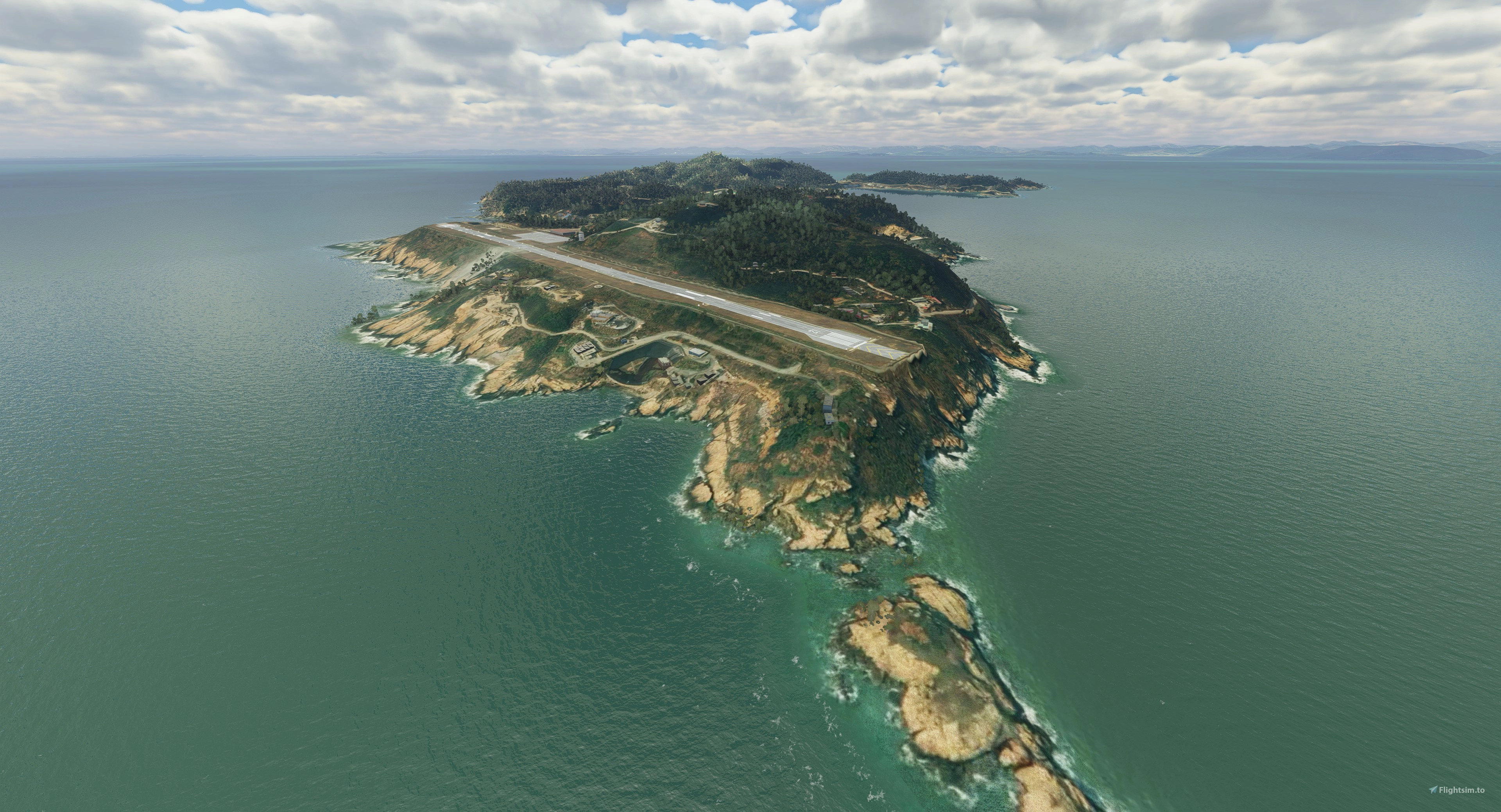
Here's a screenshot from Sloped runway tutorial showing automatically generated heightmaps that give the airfield a very detailed 5 m custom terrain mesh:

heightmaps.png


And there's much-much more.

For further information, visit:
 
Messages
34
Country
taiwan
Really appreciate this amazing tool, waiting for a usable DEM tools for a long time, trying out now.
 
Last edited:
Messages
34
Country
taiwan
Having early success with this tool is so nice. Seems TIF without rectangle shape will have some issues when converting to XML. But a rectangle one complies fine. Finding some cliff/peak in distance shows at the boundary of heightmaps, but disappear when getting close. Turn on the isolines the boundary looks like this. Do I need to setup proper falloff distance? Thanks for your hard works.


cliff2.jpg

cliff.jpg
 
Last edited:

Paavo

Resource contributor
Messages
192
Country
estonia
I'd like to have a look, if you can ZIP and upload your source imagery, border file (or coordinates) and the resulting XML. WeTransfer is a good place for that: https://wetransfer.com/
 
Messages
33
Country
germany
Wow, I've been waiting for this for a long time too. If this works, it would be a great relief. The documentation shows that extra profiles are created for the runway. I'm afraid that still no slope can be created in the transverse direction, or am I wrong there. I need for a special airfield slopes in all directions. In any case, I will try it out tonight. Thank you very much!
 
Messages
171
Country
germany
Wow, I've been waiting for this for a long time too. If this works, it would be a great relief. The documentation shows that extra profiles are created for the runway. I'm afraid that still no slope can be created in the transverse direction, or am I wrong there. I need for a special airfield slopes in all directions. In any case, I will try it out tonight. Thank you very much!
Hi,
At least one hint: You do not need to include the slope in the terraforming option inside the runway properties. You can just set a normal terraforming rectangle over the runway with the intended slope and set the priority to > 13. Better 20. Then the runway will follow this slope wihtout needed to have it in its own properties. Maybe this also works same for heightmaps?
 
Messages
33
Country
germany
Hi,
At least one hint: You do not need to include the slope in the terraforming option inside the runway properties. You can just set a normal terraforming rectangle over the runway with the intended slope and set the priority to > 13. Better 20. Then the runway will follow this slope wihtout needed to have it in its own properties. Maybe this also works same for heightmaps?

For the runway I have no profile. I am working only with the heightmap and the brush tool for this special runway. I can so create slopes in all direction, but I have to do all manualy and the work is very frustrating. So I hope with this tools I can only create a new heightmap. The runway shoild follow the contour of this heightmap.
 

Paavo

Resource contributor
Messages
192
Country
estonia
Wow, I've been waiting for this for a long time too. If this works, it would be a great relief. The documentation shows that extra profiles are created for the runway. I'm afraid that still no slope can be created in the transverse direction, or am I wrong there. I need for a special airfield slopes in all directions. In any case, I will try it out tonight. Thank you very much!
I added -nodefo option to the new release. With -nodefo defined, elev tool skips writing runway deformations (use the in-game editor to delete existing). This should give a runway that is uneven in all directions.

I have sent you a message, thanks for your help.
Your files contained a DEM GeoTIFF file and you gave its full extents as input (using -bounds). During reprojection, the image was slightly rotated and thin nodata areas appeared at the edges (see the image below). These nodata areas produced malformed heightmaps due to a bug.

I updated elev tool to skip rectangles containing areas with missing data, because height maps do not support them at the moment. If you run the same command through the new release (v0.41), it will produce rectangles depicted in yellow, skipping outermost rectangles:

map_skew.png

If you want to get as close to the edge as possible, enter bounds that are slightly smaller than your imagery. For debugging, I have added -dump option, which dumps bounds of generated heightmaps into a shapefile for easy viewing (like the yellow rectangles you see).

The best control is achieved with border polygons. I quickly drew polygons around islands, saved them into a shapefile and fed with -border to elev tool. This resulted in much fewer rectangles, closer to edges, and with no visual artifacts.
map_border.png
 
Messages
34
Country
taiwan
I added -nodefo option to the new release. With -nodefo defined, elev tool skips writing runway deformations (use the in-game editor to delete existing). This should give a runway that is uneven in all directions.


Your files contained a DEM GeoTIFF file and you gave its full extents as input (using -bounds). During reprojection, the image was slightly rotated and thin nodata areas appeared at the edges (see the image below). These nodata areas produced malformed heightmaps due to a bug.

I updated elev tool to skip rectangles containing areas with missing data, because height maps do not support them at the moment. If you run the same command through the new release (v0.41), it will produce rectangles depicted in yellow, skipping outermost rectangles:

View attachment 72801
If you want to get as close to the edge as possible, enter bounds that are slightly smaller than your imagery. For debugging, I have added -dump option, which dumps bounds of generated heightmaps into a shapefile for easy viewing (like the yellow rectangles you see).

The best control is achieved with border polygons. I quickly drew polygons around islands, saved them into a shapefile and fed with -border to elev tool. This resulted in much fewer rectangles, closer to edges, and with no visual artifacts.View attachment 72802
Thanks Paavo, that’s really a good idea to save polygons, will try it!
 
Messages
33
Country
germany
Many thanks Paavo for your amazing tool! :) With you recent update it works very fine! Before I had also mountains and valleys in some places where none should be. The new -dump otion is also very appreciated.
Now I can finally create a realistic terrain at my flying site which is crooked in all directions :)
 
Messages
118
Country
france
Man, what an incredible tool, so powerful !
Many thanks for sharing your efforts with us.
It accelerates so much our workflow :)
 
Messages
138
Country
poland
Very cool initiative, Paavo!
I have been doing all of this tiling work semi automatically with Global Mapper etc. in the past but this is of course a lot more user friendly!

Finding some cliff/peak in distance shows at the boundary of heightmaps, but disappear when getting close.

Yes, haven't been able to get rid of those in some areas neither. But didn't go into in-depth error checking with falloff distances neither yet.
 
Messages
34
Country
taiwan
Thank you Paavo, my first DEM project is released. Currently trying to see if large area of heightmaps is possible. So far success on resolution 20m (256pts x 256pts), with around 250 rectangles (~6500sq KM) is acceptable by SDK. Tried around 800 rectangles with same area but higher resolution will be rejected by MSFS SDK with error messages.
 
Last edited:
Messages
34
Country
taiwan
Congrats, Kenny!

Terrain artifacts are fixed in v0.42:

And considerations section has also been added to documentation:
https://msfs-toolkit.nool.ee/tools/elev/#considerations
Thank you Paavo,
While keep digging into it, find two things waiting for clarification.
First is the heightmap default priority is 0 and stock airport without further terraforming will be twisted with uneven surface, if I want to avoid ruining stock airports should I set heightmap priority to “-1”? Or I may be forced to hand crafted each stock airport being affected with terraforming polygons and other 3rd party airport overlap with my DEM may be affected too.
Second thing is since FS rejected too large rectangles, wondering if I separate one DEM into several xml files that limit it rectangle numbers will work?
Got work for couple days, come back later!
Thanks!
 

Paavo

Resource contributor
Messages
192
Country
estonia
Thank you Paavo,
While keep digging into it, find two things waiting for clarification.
First is the heightmap default priority is 0 and stock airport without further terraforming will be twisted with uneven surface, if I want to avoid ruining stock airports should I set heightmap priority to “-1”? Or I may be forced to hand crafted each stock airport being affected with terraforming polygons and other 3rd party airport overlap with my DEM may be affected too.
Second thing is since FS rejected too large rectangles, wondering if I separate one DEM into several xml files that limit it rectangle numbers will work?
Got work for couple days, come back later!
Thanks!

You can solve conflicts with existing airports by using in-game editor's mesh painting tools to raise/lower the terrain as you see fit.

I haven't tried different priority values and don't know if they have any meaning beyond layering of height maps, or if there is a relationship with other elements.

Likewise, limits of height maps remain unknown, but they seem to work very well for small and medium sized areas. I made a test with a region of approximately 800 sq km at 5 m resolution (2300 heightmap rects) and got perfect results. No artifacts, and while it took a minute to load the file, I even got the in-game editor to show them correctly.

I just released v0.44 with the latest tweaks @ https://github.com/noolaero/msfs-toolkit/releases

tallinn_demo.jpg
 
Messages
11
Country
norway
I'm extremely impressed by the speed of development, the quality of the tool and how easy it is to use. Since 0.41 came, I released one airport and one scenery on flightsim.to using mapheight from Norwegian authorities converted to MSFS rectangles using the toolkit.
Vaeroy, one of the Lofoten islands - in DEM3
Bringeland airport, a small STOL regional airport in Norwegian mountains, in DEM1 - around 14 sq km mesh
I haven't done any kind of editing after generating - no removal of excess rectangles (like rects in the sea) yet.

Next project is to create a DEM10 or DEM20 of a much larger area.

Thanks a lot!
 
Messages
11
Country
brazil
is there already some tutorial a little more detailed in video besides the already made available on the site? I found the tool wonderful, but I had a little difficulty understanding the flow for mesh correction around an airfield I'm developing.
 
Last edited:

Paavo

Resource contributor
Messages
192
Country
estonia
is there already some tutorial a little more detailed in video besides the already made available on the site? I found the tool wonderful, but I had a little difficulty understanding the flow for mesh correction around an airfield I'm developing.
Which airfield are you working on? Where do you get stuck?
 
Top