- Messages
- 6,523
- Country

Polygon Meyenheim.kml perhaps should be named: Polygon_Meyenheim.kml (no spaces)
Any other question that is not specific to an aspect of development or tool can be posted in the General chat forum.
By following these guidelines we make sure that the forums remain easy to read for everybody and also that the right people can find your post to answer it.


The last few months, Asobo has set a maximum line length for the XML. Paavo has created a fix for this, but this is not yet released. I don't know why, but if you're into git, you can try and download the master branch from here: https://github.com/noolaero/msfs-toolkitFollowing up on my last post I am having problems compiling my airport now after adding in the elevation data. The elevations look great when I am in DevMode and in the scenery editor. As soon as I click save scenery though in the sim the package will not build anymore and gives me an error. I can then run the MSFS Toolkit and compile the elevations again and it creates the airport xml file again and that one I can build a package without errors. Basically I am able to build the xml after I run the msfs elev tool from the toolkit but as soon as I click save scenery in the scenery editor in the SDK the file will no longer compile. I don't even have to edit anything in the scenery editor. Just one click of save scenery and it will no longer compile. Anyone have any solution to this? I have attached screenshots below of when I first build the package after running the msfs elev toolkit and then the console log after I have saved the scenery in the editor and it will no longer build.
Thank you! That appears to have been the issue. I downloaded the master branch and the file compiles again after saving in the scenery editor! I would have never found this solution as I am not really a big Github user. Now I will make my edits again that I was working on and save and hopefully it will keep working!The last few months, Asobo has set a maximum line length for the XML. Paavo has created a fix for this, but this is not yet released. I don't know why, but if you're into git, you can try and download the master branch from here: https://github.com/noolaero/msfs-toolkit
Issue: https://github.com/noolaero/msfs-toolkit/issues/1
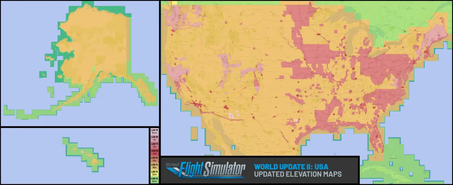
 apps.nationalmap.gov


Hi,Non appena inserisco questo comando msfs project -type scenario -id LFSC -name "marcstrasb-base-lfsc" -title "LFSC Base" -creator "marcstrasb" -aerial "LFSC Aerial Base" ho il seguente risultato (vedi il screenshot allegato):
Run Sfc Scannow from WindowsThank you for your help ! I did as you said by putting ".\" in front or doing with the full path of the exe, I end up with this answer: CHCP is not an internal or external command.
Regards,
Marc


Hello, Bavarello. I've tried to used this tool to exclude my airport, but it give an error: Terminating translation prematurely after failed translation of layer polygon, just as the picture shows.Thanks you @Paavo,
with the -exclude option in MSFS Toolkit version 0.47 add another piece for this great tool.
Excluded Areas
When developing a regional terrain that covers multiple airports (without including them), you may want to cut out holes around airports to avoid conflicts with third party airport packages.
You can use -exclude option to assign a vector file with polygons that define excluded areas. All heightmap rectangles overlapping with those polygons will be skipped.
Border (red) + exclusion (yellow) = grid (green)


 + exclusion (yellow) = grid (green)")