Water color light to dark- could you smudge between the two like you would in your tif? I did something similar at Alameda working on the bmp to blend the lighter water to darker. I lowered opacity and hardness for a bit more control and also so I could see the moving water from FSX through it all. Could that help? Bob
That might help. But the method we are using has to do with feathering the edges of the Blendmask.bmp we create in the tutorial. It is 25-75% black on pure white, drawn along the lines where you want the transition to shallower water to fall. Then it is filled in. We played with the airbrush setting, inverting the foreground color to black and background color to white. Then after adjusting the settings as desired for things like Rate and Flow, I just have to 'paint' with the airbrush along the hard edge of the black border. It applies a white gradient that keeps getting lighter if you go over it more than once.
Once the Blendmask.bmp is reworked like above, the resample.exe utilty (from the FSX SDK) is used to process it, the Watermask,bmp (which you draw and fill to tell FSX where the water's boundaries are) and the base image layer (gathered from satellite imagery by SBuilderX313) and it chews on them for awhile and spits out the required BGL file to make it all appear in FSX once you load it in the Scenery Library.
The Blendmask layer is partially transparent as seen by FSX, so it lets the underlying coloring show through a little, depending upon what percentage of black is there. Where problems start is when the water in the satellite imagery is white or shiny silver, like it was in the poorly rendered imagery around Long Point. I had to erase all that from the base photo layer bitmap and fill the area in with a dark blue-green color, because it was trying to make the shallow water look like dayglo powder blue.
")
Not very realistic for that part of the world.
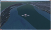
I attached a couple pictures to show what I am doing. This is for part of the Erie PA harbor area. Blendmask B4 Gradient is the one used prior to developing our technique, and it yields very definitive changes in color in the main basin of the bay. I'll try to get some screen shots later, but I would need to load the old scenery files vs. the new scenery files to show the differences as seen in FSX. The Blendmask Gradient picture is what the edges of the blendmask look like after we do our voodoo. Note the fuzziness in the basin area. This is where the water makes its gradual color change, which you will be able to see once I post the screen shots.
When we don't want the wide gradient, such as the hard edges of shipping channels or against deep water piers or cliffs, we leave out the gradient in that area.
Edit : I just added more photos, showing Erie PA using the 2 different kinds of blendmask files. I also added a photo showing how the underlying image color changes can affect how the water looks when the tutorial is used to make the scenery. In this example our gradient was applied. But I need to go back and actually edit the colors at the point where these two BGL files meet, to try and obscure this issue a bit. As far as trying to get the color tones on the LAND imagery to match up across BGL areas, that is a whole different kettle of fish. Anyone who has worked with these satellite images can attest to that! The colors will vary, sometimes a lot, from area to area. It usually isn't easy, or practical, to try to match them up when there are wide variances.