• Which the release of FS2020 we see an explosition of activity on the forun and of course we are very happy to see this. But having all questions about FS2020 in one forum becomes a bit messy. So therefore we would like to ask you all to use the following guidelines when posting your questions:

    • Tag FS2020 specific questions with the MSFS2020 tag.
    • Questions about making 3D assets can be posted in the 3D asset design forum. Either post them in the subforum of the modelling tool you use or in the general forum if they are general.
    • Questions about aircraft design can be posted in the Aircraft design forum
    • Questions about airport design can be posted in the FS2020 airport design forum. Once airport development tools have been updated for FS2020 you can post tool speciifc questions in the subforums of those tools as well of course.
    • Questions about terrain design can be posted in the FS2020 terrain design forum.
    • Questions about SimConnect can be posted in the SimConnect forum.

    Any other question that is not specific to an aspect of development or tool can be posted in the General chat forum.

    By following these guidelines we make sure that the forums remain easy to read for everybody and also that the right people can find your post to answer it.

FSX Skewed background image <fixed>

  • Thread starter Thread starter Taylor
  • Start date Start date
Hi Gary,

Sounds good. And thank you. As I'm sure you know, I have my plate full just learning the basics. I was aiming to keep the learning workload to a minimum, but what the heck, I've got the time for it and there's no rush.

Taylor
 
Hi Taylor:

The initial test compile of a local area high resolution terrain mesh BGL is ready for you to download; I've sent you a link in a PM. ;)


PS: Think of it as a "MASH-mesh" (...or was that a "mesh-MASH") ! :D


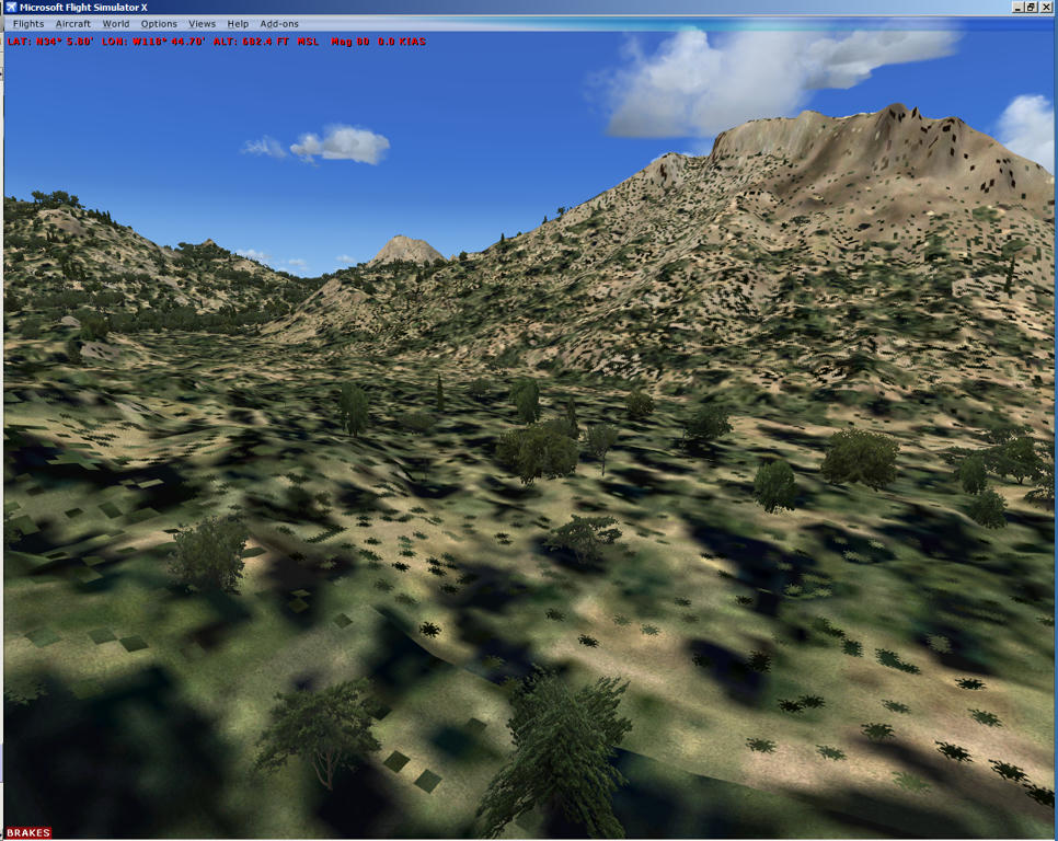
Oh, and here's a screenie of how the custom terrain mesh looks: :idea:

r9t892mtqysbr096g.jpg


GaryGB
 
Last edited:
Hi Gary,

Wow, the detail is amazing. I'll have to relocate the helipad and fix the mesh so it blends, same with the creek. This is awesome :D
garymesh.png


How large of an area does this cover? I don't want the file sizes to be ginormous or anything, but there is a lake to the NW of the camp with a small island in the middle that doesn't show up on this .bgl. I'm thinking I might want to extend the creek around the mountain to show the water source. Not a big deal at this point though.

Thanks!

Taylor
 
Here's a screeny with Malibu Lake in the background. Looking at satellite images of this area at different times of season shows Malibu Creek with and without water...sometimes it's a creek, sometimes it's a ditch. So, if we want to be uber technically correct (which I'm not real interested in) there needs to be a seasonal variation applied to the land class/water class map, no?
malibulake.png
 
Hi Gary,

Wow, the detail is amazing. I'll have to relocate the helipad and fix the mesh so it blends, same with the creek. This is awesome :D


How large of an area does this cover? I don't want the file sizes to be ginormous or anything, but there is a lake to the NW of the camp with a small island in the middle that doesn't show up on this .bgl. I'm thinking I might want to extend the creek around the mountain to show the water source. Not a big deal at this point though.

Thanks!

Taylor

I'll take a look at the data set this weekend, and will see if "portions" of that potential 4GB fully-decompressed size can be better localized to cover only the more scenic areas up to the borders of the urban areas at ex: road edges, so that the non-urban areas can be shown without an otherwise immense terrain mesh BGL file size.

In theory one might still see a good result in FSX at run time using 40% compression for terrain mesh, but I'd have to check and see if the preferred existing 2 Meter mesh details are lost or distorted if a 40% compression is used in the BGL.

I'm guessing since you "don't want the file sizes to be ginormous", we might be setting a goal of having a terrain mesh BGL size of less than 500 MB (..or perhaps even smaller ?) :scratchch

On a practical basis though, even with the fair-sized surrounding area already covered in the initial mesh file, it was only around 6.5 MB in size, so we should be able to easily cover much more of this interesting scenic area without incurring a huge terrain mesh file size hit. ;)


Here's a screeny with Malibu Lake in the background. Looking at satellite images of this area at different times of season shows Malibu Creek with and without water ...sometimes it's a creek, sometimes it's a ditch. So, if we want to be uber technically correct (which I'm not real interested in) there needs to be a seasonal variation applied to the land class/water class map, no?
Correct; this can be done using a graphics application ex: Photoshop / Gimp / Paintshop Pro / PhotoPaint etc. to edit copies of the original aerial imagery to create the seasonal variations ...and if desired, the optional night texture (aka "LightMap").

CAVEAT: When editing the copies of the original aerial imagery, one will need to NOT re-size the pixel dimensions of the BMP files, so that they can used with the same original Geo-referencing TXT file (which SBuilderX writes into the downloaded tile folder along with the original aerial imagery BMP file).

Hope this helps ! :)

GaryGB
 
Last edited:
Back
Top