Hi Gary,
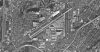
Got your message from the other thread. Yes, I like to learn how I can cover a portion of that image. First of all, look at this image of the KBHM ADE file I'm creating using the alignment satellite map:

I hope this image is large enough for all to see. The alignment map is from 2002 and shows the runway extensions on the map. But if you look carefully at the runways in ADE, they show what the runways looked like between the years of 1960s to the late 1980s. I think it was in the early 1990s when runway 36/18 was extended from 4,856 to 7,100 feet. And around 2003, runway 6/24 was extended from 10,000 to 12,000 feet. You can actually see the construction of that in the satellite view you sent me. Runway 6/24 was actually 5/23 in those days. Runway 6/24 was lengthen on the N.E. side and runway 36/18 was lengthen on the south end of the runway.
Since if have the Alabama photo scenery installed, it shows the lengthened runways as of 2013. What I want to do is to take out those runway extensions from the MagaSceneryEarth Scenery so that it's the same length as it was in the 1970s and 1980s, and yet still have my Alabama scenery. Since you said ADE will not overwrite the runway extensions using the polygons I described in the other thread, the only way I know I can do that is to take that image and use Gimp to photo shop the runway extensions out, and I guess that's what you're referring to when you suggested that I use the SDK Autogen Annotation you described in the other thread.
I finally found the tile image file name and it's not a texture file but a bgl file. The file name is AL Areial1_I_11.bgl. When I have it on the screen, it show grids outlined in red dashes. I assume each bgl file represents 1 tile. I tried using that application but I don't know how I go about taking that image, photo shopping it, and replacing the other file. Is that how I need to do it? If so, this is what I need help with.
Oh, by the way, do you know where I can get a good hi resolution satellite image of the airport from the 1980s, one that does not have a bunch of crap written all over it, and one that does not charge $40.00 a month just to be able to download the images. That one is the one I really need.
Ken.
Got your message from the other thread. Yes, I like to learn how I can cover a portion of that image. First of all, look at this image of the KBHM ADE file I'm creating using the alignment satellite map:
I hope this image is large enough for all to see. The alignment map is from 2002 and shows the runway extensions on the map. But if you look carefully at the runways in ADE, they show what the runways looked like between the years of 1960s to the late 1980s. I think it was in the early 1990s when runway 36/18 was extended from 4,856 to 7,100 feet. And around 2003, runway 6/24 was extended from 10,000 to 12,000 feet. You can actually see the construction of that in the satellite view you sent me. Runway 6/24 was actually 5/23 in those days. Runway 6/24 was lengthen on the N.E. side and runway 36/18 was lengthen on the south end of the runway.
Since if have the Alabama photo scenery installed, it shows the lengthened runways as of 2013. What I want to do is to take out those runway extensions from the MagaSceneryEarth Scenery so that it's the same length as it was in the 1970s and 1980s, and yet still have my Alabama scenery. Since you said ADE will not overwrite the runway extensions using the polygons I described in the other thread, the only way I know I can do that is to take that image and use Gimp to photo shop the runway extensions out, and I guess that's what you're referring to when you suggested that I use the SDK Autogen Annotation you described in the other thread.
I finally found the tile image file name and it's not a texture file but a bgl file. The file name is AL Areial1_I_11.bgl. When I have it on the screen, it show grids outlined in red dashes. I assume each bgl file represents 1 tile. I tried using that application but I don't know how I go about taking that image, photo shopping it, and replacing the other file. Is that how I need to do it? If so, this is what I need help with.
Oh, by the way, do you know where I can get a good hi resolution satellite image of the airport from the 1980s, one that does not have a bunch of crap written all over it, and one that does not charge $40.00 a month just to be able to download the images. That one is the one I really need.
Ken.
Last edited:


")


")