- Messages
- 5
- Country

Hi, i was updating a stock p3d airport to make it uptodate. but the runway numbers are not showing correctly in the sim. The runway is 27-09. It is correctly showing in ADE
Any other question that is not specific to an aspect of development or tool can be posted in the General chat forum.
By following these guidelines we make sure that the forums remain easy to read for everybody and also that the right people can find your post to answer it.

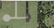
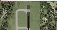
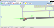
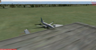
like you said i tried removing the background satellite image and made the changes, but the issue did not fix. I also tried flattened the surface using the polygon tool at the exact points of the runway but it is not fixed. I will also attach the ADE file if you would like to take a look.I assume the default rwy screenshots are the 2 on the left above and the 2 on the right are ADE along with a satellite image as background??
What you are seeing is a combination of uneven terrain that comes with the background image where as your ADE version is not the same terrain variation so what is on the attached image is what I call "bleed thru".
If you are going to attach a satellite image that contains a runway and you are wanting to "add" your own runway over the top, any terrain changes have to be configured into ADE. The other option is to add with ADE a "flattened" background that EXACTLY matches the same runway points on the globe and then ADD your own ADE runway within the flattened area. This issue does not come into play with taxiways or paths as they are not a "precise" entity.
To prove this, as I have gone thru similar, remove the background satellite image and add your "updates" to the stock runway, along with all comms, etc.
")
v4What version of P3D?
I fixed all the things you said and now the runway numbers are showing correctly. But there is another issue, the ground textures disappear when looked from some particular camera angles. When i watched a tutorial the guy said if the ground textures are not showing correctly we have to use the polygon tool and create a flattened surface, i did try that. How can i fix that? Thank you very much for your help. And for the background satellite image, aren't they just for a reference while building the airport and they don't actually compile with the scenery right? Because there weren't any background satellite imagery showing when i first compiled the airport even though the satellite image was in the ADE while compiling.OK, there are a significant number of incorrect things in your ADE. I have looked into this with P3Dv5.4 and your ADE shows that same as it does on your v4. Thats the good news.
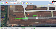
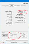
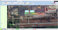
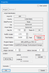
The airport that you sent to me in your ADE is far from correct. The runway 09/27 is not in the correct position or heading. It should be at Latitude 10.151112378 and Longitude 76.400508285 and heading 87.870003. The real issue is that you have marked the runway as STOL (Short Takeoff Or Landing) and this runway is 11,154 foot long (STOL runway length is 2,600 feet or shorter). Remove STOL setting via ADE (see attached) and your RWY IDs will show correctly. The reason there was overlap of number and letters on RWY 9 and not on Rwy 27 was due to you selecting STOL for the Primary but not the secondary.
If you plan to use a background image, runway and taxiways need to be in the correct position (Long/Lat). At your current placement, your RWY is in the "Lotus Pond".
Hope this helps. See attached.
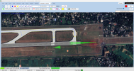
So i guess the default coordinates itself are wrong, because i didn't change any coordinates while editing the scenery. In the first attached screenshot i freshly opened the stock airport and added the background satellite image, and it looks like that. So what you said about the runway being in a 'lotus pond' and above a multi lane national highway makes sense now. Also the apron sits above the airport buildings and some solar panels in the stock scenery. I saw this problem initially and i thought i just entered the satellite image coordinates wrong and i just dragged the image to align with the stock airportWell, you have apparently changed not only the RWY location (Long/Lat) but also the physical location of the entire airport. If you position the airport in the correct location, remove the 2 overlapping airport background polys, and construct an Airport background poly "Flatten Mask Class Map Exclude Autogen Smooth, you will find the problem you stated above goes away.
I really dont understand why both the airport location and the runway location were changed. The way it currently is configured, the airport sits directly on top of a major north south multi lane highway.
I would strongly suggest that you start with the STOCK airport and then make your modifications.so i
and build it from there. I will change the coordinates to its correct ones and will try to make the scenery better, Thanks for your help.